Download Detail Study – Section 6 (PDF)
INTRODUCTION AND BACKGROUND
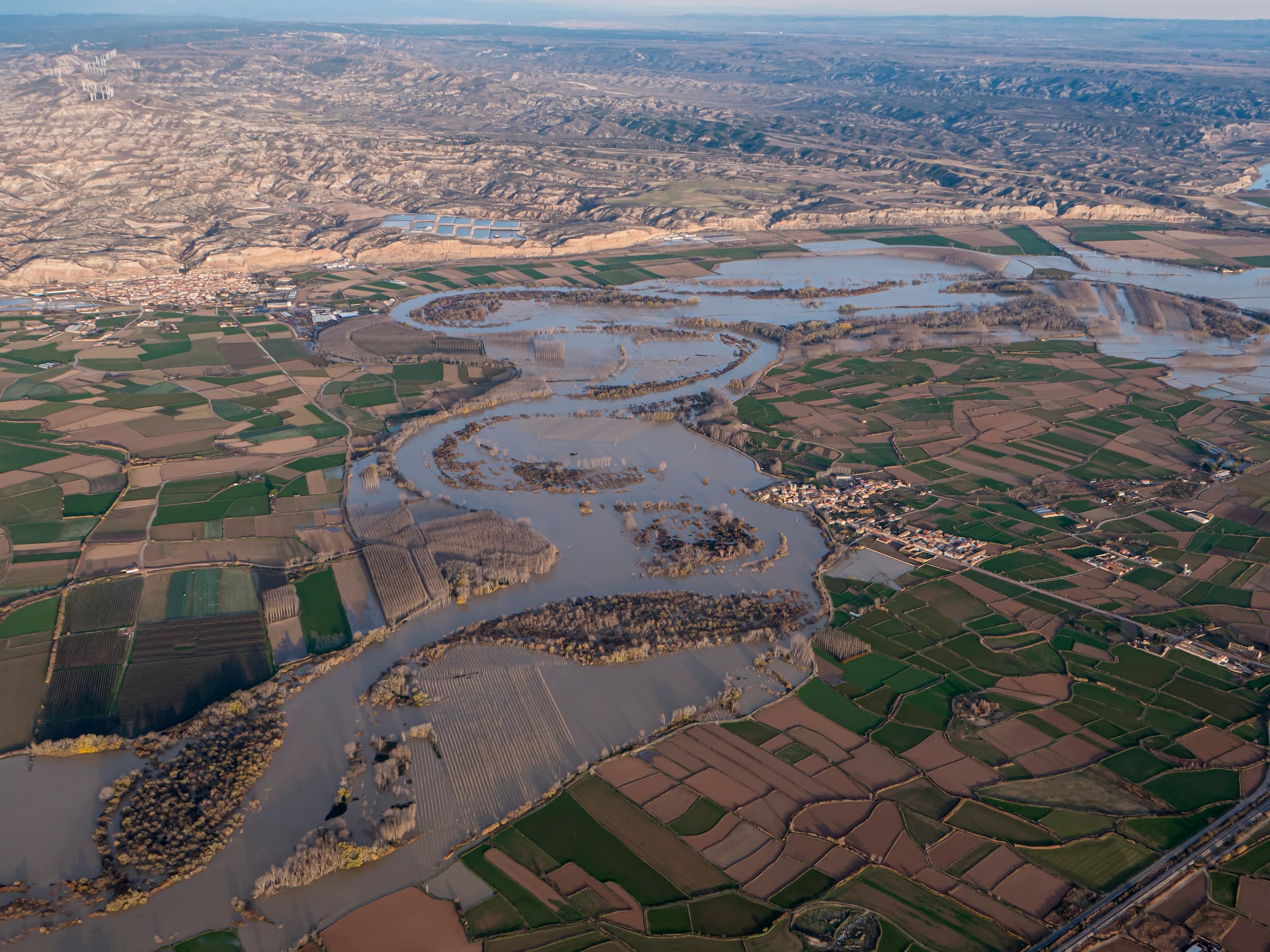
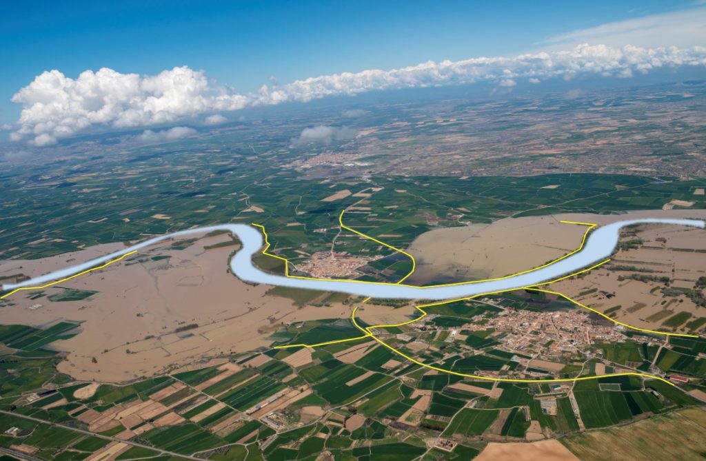
Within the scope of the Ebro Resilience Strategy, a total of 260 kilometers of the Ebro River are being studied, divided into 16 sections. Section 6 comprises the course of the Ebro River as it passes through the towns of Pradilla de Ebro and Boquiñeni, with a length of 16 kilometers and running through the municipalities of Gallur, Pradilla de Ebro, Boquiñeni, Luceni and Tauste (Figure 1).
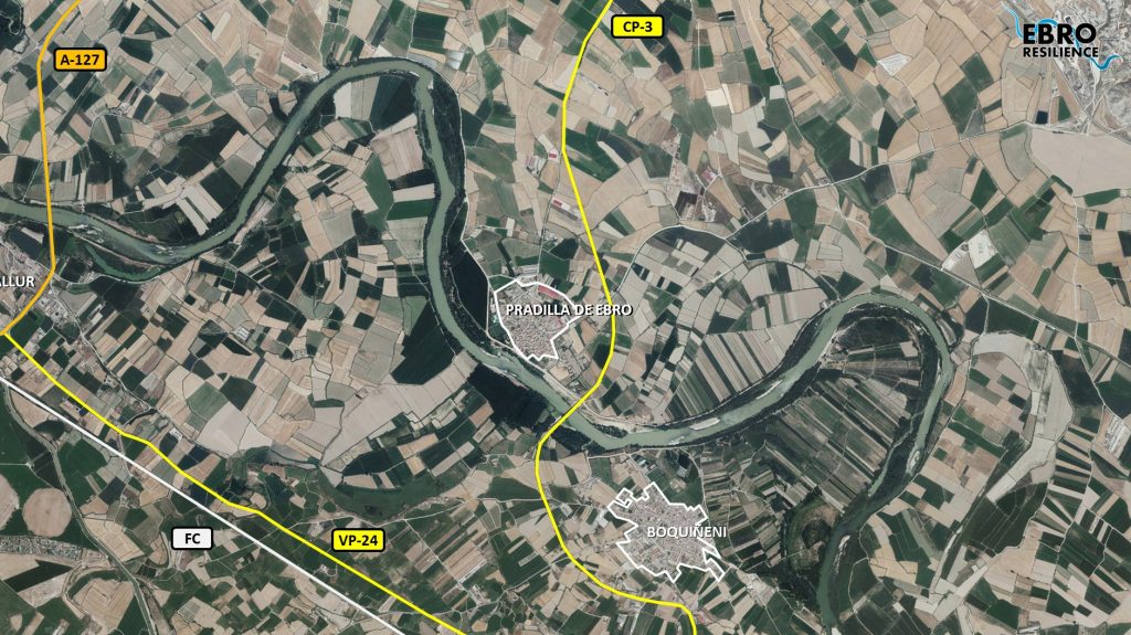
The towns of Pradilla de Ebro and Boquiñeni are located on a fluvial terrace0F[1] that forms in this section a natural narrowing that begins upstream of the town of Pradilla de Ebro and ends in the meander downstream of Boquiñeni (figure 2).
However, extraordinary floods have been able to exceed the level of this first terrace on several occasions, forcing the evacuation of Pradilla de Ebro in 1961, 2003 and 2007 and both in 2015.
Starting in 1961, defense dikes began to be built to protect both urban centers and agricultural fields from the most recurrent floods. However, these infrastructures limit the floodplain, reducing its hydraulic section, which results in an increase in the height of the water in a flood situation. As a result, when the capacity of the defenses is exceeded, major flooding occurs. Being an area with a high risk of flooding and two urban centers being affected, numerous interventions aimed at flood damage reduction have been carried out from 2003 to 2018 (Figure 3). The interventions carried out include different typologies, from classic actions such as reinforcement of existing defenses, construction of new ones and dredging, to novel techniques such as temporary flooding areas1F[2], creation of safety perimeters2F[3] and vegetation treatments with the curage technique3F[4].
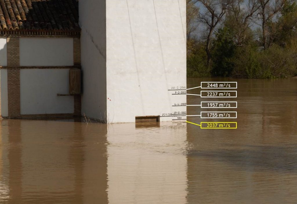
These actions have led to significant improvements in the flow behavior during floods, increasing the drainage capacity of this section and reducing the height of the water during the passage of the floods. This could be seen in the 2018 flood, where the levels reached by the river were reduced by up to one meter compared to similar floods (Figure 4).
At present, the drainage capacity of this section has been improved to a certain extent and there would no longer be any impact on urban centers for 10-year return period floods. However, the narrowing formed by the system of motes downstream of Pradilla de Ebro continues to exist and, in the event of higher flows, both urban centers could be affected.
A possible rupture of these motes, due to overflow or collapse, would mean a sudden flood with a very high water level, with the consequent risk. On the other hand, the high water level increases seepage problems, which end up reaching the urban centers, and could also cause problems of collapse of the defenses due to subsidence.
WORK PERFORMED
For the preparation of the study, a series of technical studies have been carried out using the latest available technologies, which have made it possible to evaluate the current situation of the section with respect to the objectives set. Once the current situation has been evaluated, different alternatives for action have been studied, individually and in combination, selecting those that have produced the desired effects and discarding the less favorable or counterproductive ones.
Digital Terrain Model (DTM)
One of the works carried out for the study is the elaboration of a digital terrain model4F[1] (called DTM) that reproduces the current situation. It is important that this DTM faithfully reproduces the conditioning factors of the river section under analysis, and for this purpose the work listed below has been carried out.
First, the terrain is reproduced on a large scale, using LIDAR5F[2] topography, which consists of a scan of the terrain using aerial means (normally a light aircraft is used for large surfaces, but drones are commonly used).
Next, the topography of the most important elements for the study is obtained, such as: the crest of the dikes, walls, breakwaters, bridges, drains, relief channels, safety perimeters, etc. This work has been carried out using classical surveying methods, increasing the accuracy of the data on these key elements.
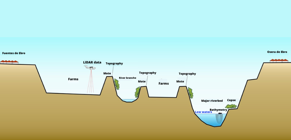
The above methods have the disadvantage that they are not able to obtain data from the ground beneath the water. This has been the main drawback
flooding studies have been conducted previously. Technology is now available to obtain the topography of the river bed in a continuous manner. Como novedad para estos estudios realizados en el marco de la Estrategia Ebro Resilience, se han utilizado medios acuáticos dotados de un sonar6F[1] para la toma de datos batimétricos7F[2] del lecho del cauce, incorporando estos datos al estudio. The data obtained are combined for the elaboration of the DTM (Figure 7).
The DTM analysis allows corroborating the existence of the terrace levels and detecting the old river courses. The presence of the defenses on the flood plain of the river, with a much lower elevation, is noteworthy.
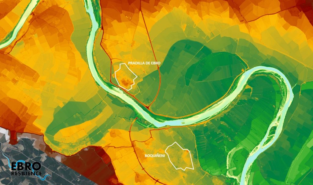
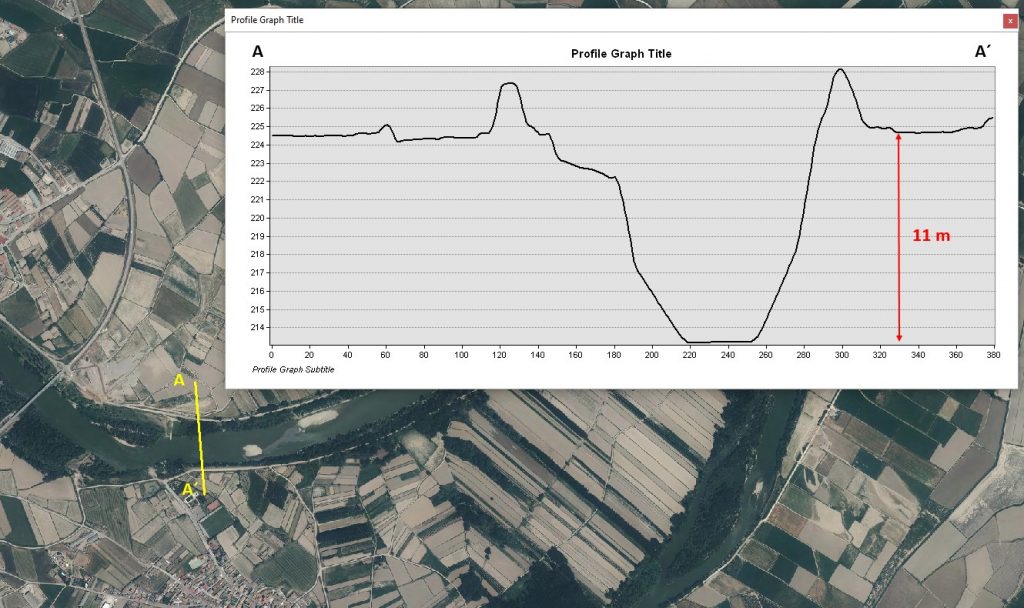
On the other hand, the bathymetry shows the existence of erosive processes in the area around the narrowest part of the channel, downstream of the CP-3 road bridge and in front of the town of Boquiñeni. This narrowing implies an increase in current velocity and greater erosion. This translates into a greater incision of the riverbed at this point, with the bed 11 m below the terrace on which sits the mote that defends the urban center of Boquiñeni (Figure 8). Although this defense is located on conglomerate strata, further erosion increases the risk of foundation collapse of this infrastructure.
Hydraulic model
The next step of the study is the analysis of flooding episodes. Hydraulic models are used for this work, which consist of a computer tool that applies a given flow rate to the DTM and reproduces the effects of flooding8F[1].
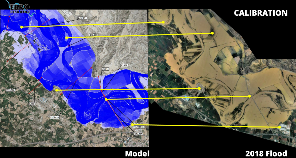
These computer tools require a process called calibration to adjust the results obtained to the characteristics of the section under study. In this case, the aerial photos of the avenue from April 2018 and December 2019 were used, achieving a good calibration.
Once the hydraulic model has been configured and calibrated, the target flood is reproduced , in this case the one corresponding to a return period of 25 years, which in this section is equivalent to a flow of 3,100 m3/s, and the effects produced on urban areas are analyzed.
With respect to the problems that may be caused by possible overflows, it should be borne in mind that the hydraulic model considers the terrain to be rigid, i.e., the motes do not collapse at any time, even if they are overflowed. To compensate for this circumstance, the flood peak in the simulation will be prolonged in time, achieving flooding effects similar to those produced in a real event.
The result of the modeling is discussed in section 4 “Study of Alternatives”.
STUDY OBJECTIVES
In accordance with the Ebro Resilience Strategy, the specific objectives of the study were as follows:
- Evaluate the level of protection of urban areas for floods with a return period of 25 years, which corresponds to a flow of 3,100 m3/s in this section.
- Propose actions to prevent flooding, in the event of flooding.
- Reduce damage in non-urban areas for a 10-year return period flood, which in this section is equivalent to a flow of 2,700 m3/s.
The study has a pre-project level, being determined to select the most suitable alternatives and to allow the environmental evaluation of the proposed solutions. The definition of the exact dimensions of the actions to be carried out and their details must be included in the corresponding construction project.
STUDY OF ALTERNATIVES
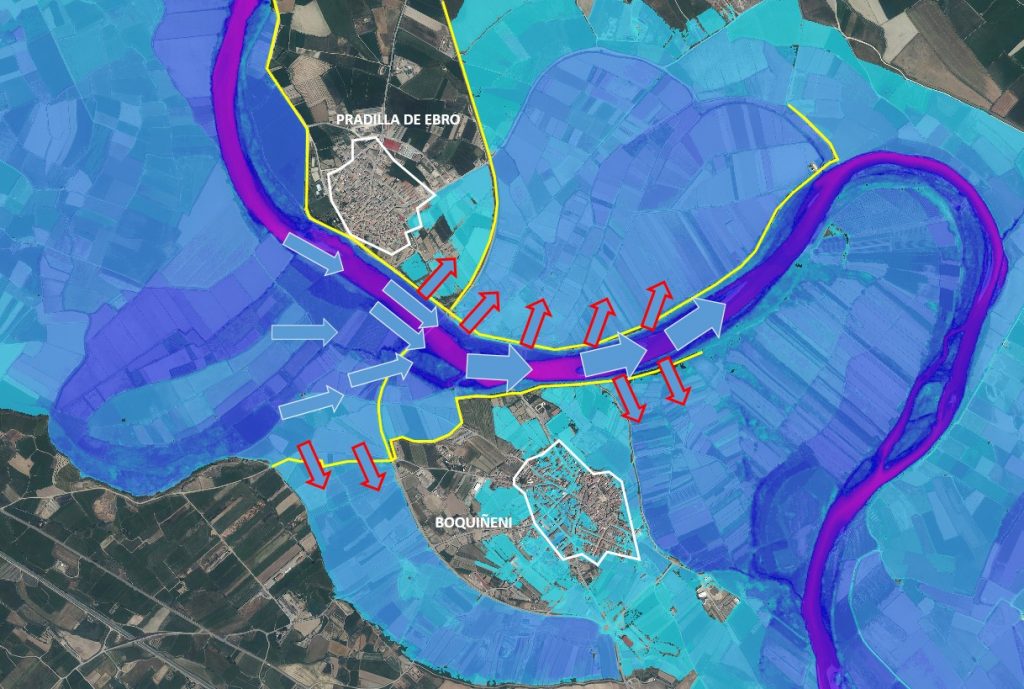
The analysis of the simulation of the target flood for a return period of 25 years (3,100 m3/s in this section) concludes that the urban centers of Pradilla de Ebro and Boquiñeni would be directly affected by surface flooding (Figure 10).
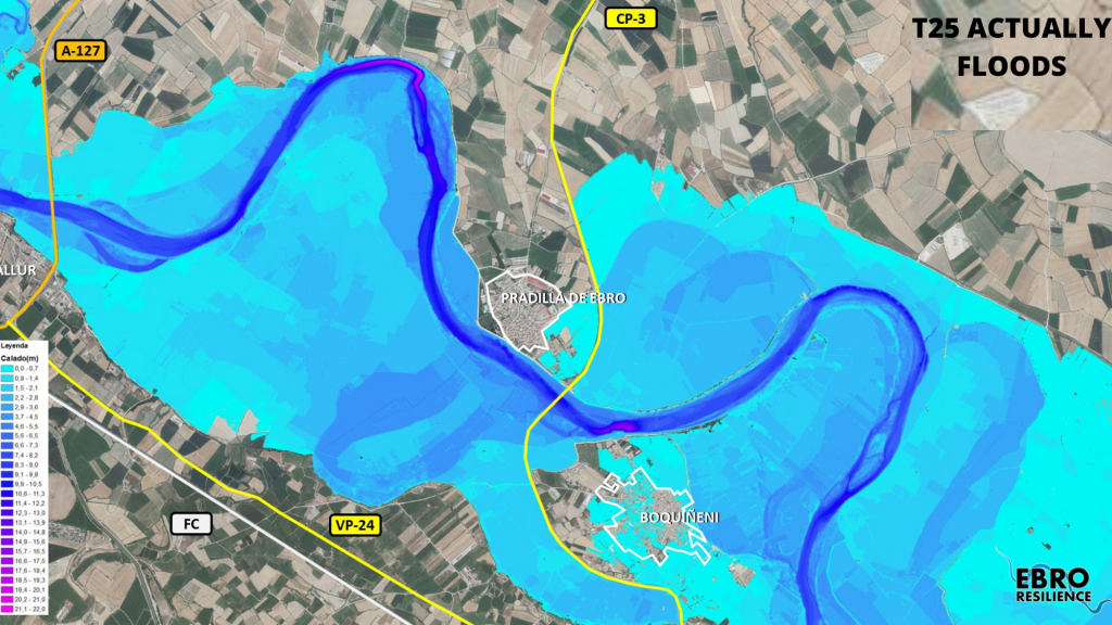
Downstream of the CP-3 road bridge, the space between longitudinal defenses is reduced to 166 m, being one of the largest narrows in the middle section of the Ebro. The river’s drainage capacity is impaired at this point. The narrowing acts as a funnel and the waters are dammed in the upstream section, increasing the risk of flooding in Pradilla de Ebro and Boquiñeni (Figure 11). In the latter locality, the paleochannel that surrounds the urban center on its southwest side, next to the bypass, and which is located on an upper terrace, would come into operation. This fact already occurred in the 2015 avenue.

In the case of Pradilla de Ebro, the flooding is caused by the overflowing of the defenses immediately upstream of the CP-3 bridge.
In the case of Boquiñeni, flooding occurs from the paleochannel that surrounds the town to the south. The flood is capable of overflowing the constructed closure, entering this paleochannel. Once it reaches the CP-3 road, the frames built in 2015 are insufficient to drain the incoming flow and the road overflows into the urban core.
Alternatives with dredging actions
Although dredging interventions have already been carried out in the section studied (Figure 3), which were not very effective and with an annual durability, two sediment removal interventions have been studied in the surroundings of the Boquiñeni meander in response to the requests received from the Boquiñeni town council. The study was carried out by the Polytechnic University of Catalonia, due to the complexity and specialization required for an analysis of this type.
In the first of these (shown in yellow in Figure 12), 580,000 m3 of sediments would be removed. In the second of these, the volume withdrawn would increase to 1,500,000 m3 (in red in Figure 12).
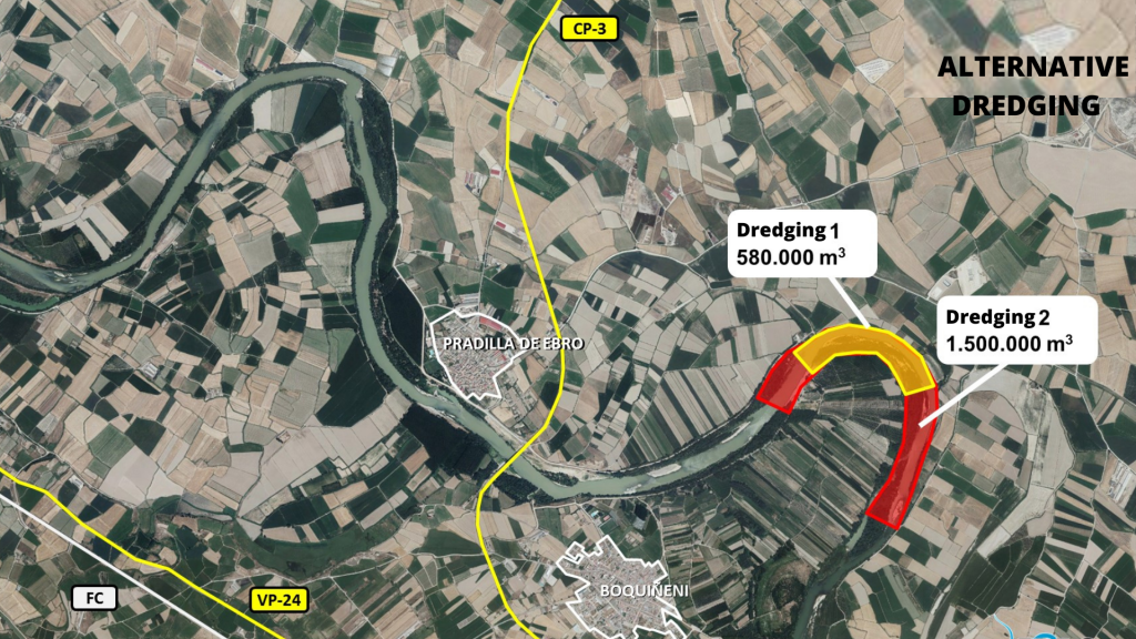
The conclusions of the studies are as follows:
| Dredging 1 | Dredging 2 | |
| Volume | 580.000 m3 | 1.500.000 m3 |
| Result | Lowering of the water level by 20 cm immediately upstream. Both urban centers would continue to be flooded. | Lowering of the water level by 70 cm immediately upstream. Both urban centers would continue to be flooded. |
| Durability | 10 days of Q = 2,000 m3/s | 25 days of Q = 2,000 m3/s |
| Cost | 9.000.000 € | 25.000.000 € |
| Meets objectives | No | No |
The effectiveness of dredging is limited to the immediately upstream section and has a very short durability, ten days of flooding for dredging 1 and 25 days for dredging 2. The study analyzed the effects of durability in the event of a 2,000 m flood.3s, but it has been found that in the Ebro from flow rates of around 400 m3 /s, the flow rate of the Ebro is higher than that of the Ebro, and the flow rate of the Ebro is higher than that of the Ebro.3/s sediment mobilization is already occurring, so that in practice the durability of the intervention would still be lower than indicated in the result of the study.
This alternative does not solve the flooding problems of the urban centers and, consequently, has been discarded.
Alternatives studied
Firstly, several alternatives have been studied to reduce the backwater produced by the system of defenses in a flood situation at the height of the urban centers.
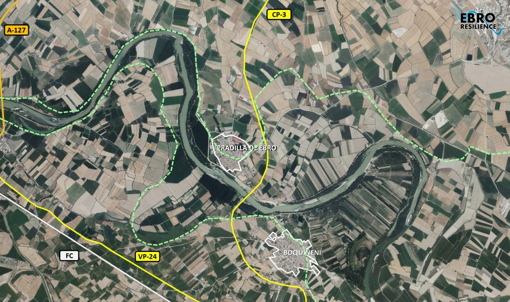
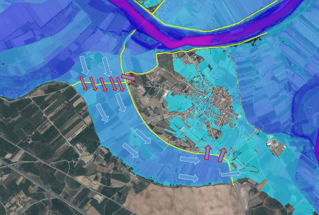
An analysis of the results of the hydraulic model shows that the narrowing of the defense system produces a significant over-elevation of the water level in the upstream section, increasing the pressure on the defenses of the urban centers. According to the model, this circumstance originates the diversion of water towards the urban center of Pradilla de Ebro and towards the paleochannel that surrounds Boquiñeni to the southwest (Figure 13).
Although the hydraulic model does not reflect this, it should be borne in mind that the overflowing of an earth mote usually implies its rupture, with the consequent entry of water at a high level and at high velocity. This entails serious risks for the population because the flooding occurs suddenly and with great dragging capacity. In addition, it involves
The material damage is much greater due to the great erosive power of a current of this type.
Finally, even if overtopping does not occur, defenses that attempt to contain a large flood present a greater risk of collapse. Higher water pressure increases seepage both through the body of the mote and below its foundation. The outcropping of these seepages behind the defense drags material and reduces the bearing capacity of the soil, which could lead to the collapse of a section of the defense. In this case, the breakage occurs even more suddenly.
To try to alleviate this situation, various alternatives have been studied, such as setbacks of different magnitudes in the Pradilla orchard or relief channels with different locations in the Boquiñeni meander.
On the other hand, the paleochannel that surrounds the urban core of Boquiñeni has a closure at its entrance that was executed in 2015. However, for floods with a return period of 25 years, this defense is overwhelmed. Once the overflow of this defense occurs, the waters circulating through the paleochannel can only exit through the frames that were built in the area where the access road to the town was broken during the 2015 flood. However, these frames are insufficient to evacuate these flows, causing the road to overflow into the urban center (Figure 14).
Recreating the closure of the paleochannel is not a viable solution, since it would increase the risk of overflowing the road to the northwest of the urban center, so that the overflowing waters would reach the urban center from upstream, with the risk that this entails. In fact, the entry of water through the paleochannel reduces the risk of overflowing this sector of the Boquiñeni defenses.
On the other hand, it is necessary to be prepared for an eventual breakage of this closure, since it is a land defense with the aforementioned problems.
Therefore, different alternatives have been studied to avoid the overflow of the road towards the urban center, also considering possible breaks in the closure of the paleochannel.
Description of the proposed alternative
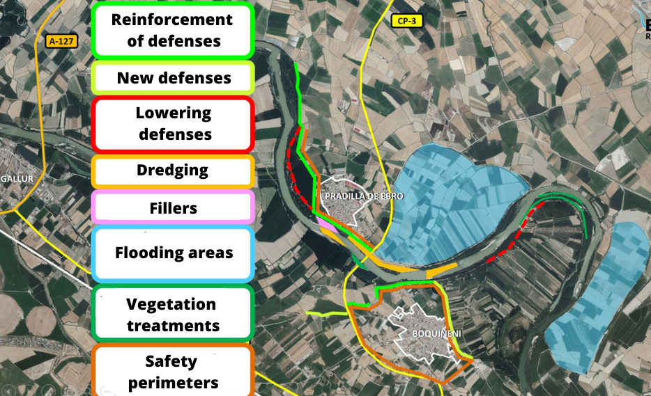
The alternative that has been shown to be the most efficient in the simulations and that meets the established conditions is a combination of interventions as follows (Figure 15):
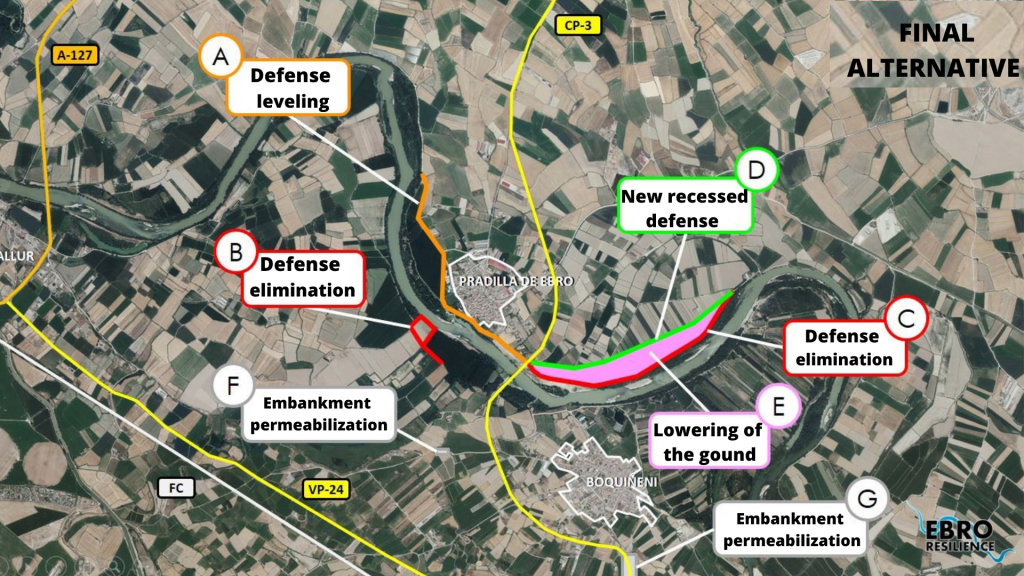
A. Leveling of the Pradilla de Ebro defense mound to increase the security of the urban nucleus.
B. Elimination of the obstacles located on the right bank of the river and that delay the entry into operation of the Los Fornazos storage shed.
C. Retrenchment of the Pradilla orchard mote to eliminate the narrowing that acts as a funnel and reduces upstream drainage capacity.
D. Construction of a new recessed defense.
E. Lowering of the ground in the space freed up, which will further increase the drainage capacity in this narrowing.
F. Installation of a battery of frames, closed with a concrete block wall, in the Boquiñeni paleo-watercourse closure mound. These frames would come into operation, breaking the block wall, when the waters threaten to overflow this infrastructure or when it is necessary to lower the flood level on the western front of the urban core defenses.
G. Installation of a battery of frames on the access road to Boquiñeni, in order to drain the flows that flow through the paleochannel, either by the opening of the frames located upstream or by breakage or overflow of the closing mote. These frames will prevent the road from behaving like a dam and eventually overflowing into the urban core. These crossings would also remain closed on small avenues.
Cost-benefit analysis
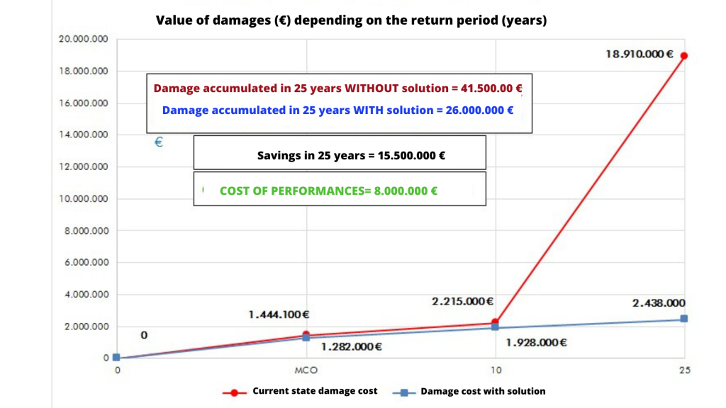
The proposed alternative would have an estimated implementation cost of €8,000,000, including the acquisition of the necessary land.
According to the cost-benefit analysis carried out, the implementation of the proposals would save €15,500,000 in damages over a period of 25 years, compared to the current situation. For this comparison, the damage declared in the 2018 floods in crops, the costs of repairing infrastructure and the possible damage in urban areas according to the height that the waters would reach have been taken into account.
CONCLUSION
The alternative selected as the most efficient would prevent the flooding of the urban centers of Boquiñeni and Pradilla de Ebro for floods with a return period of 25 years, achieving the objectives initially proposed.
In addition, the flood height over the fields is reduced in a significant percentage (70% 920 ha) of the farms in the section under study for the target 10-year return period flood. A lower water level also reduces the risk of fender failure and seepage.
The study has a pre-project level, being determined to select the most suitable alternatives and to allow the environmental evaluation of the proposed solutions. The definition of the exact dimensions of the actions to be carried out and their details must be included in the corresponding construction project.
The execution of these actions must be associated with a follow-up of their evolution that will make it possible to verify that the objectives pursued are achieved.
WHAT NOW?
Once the detailed study of the section has been completed, deliberative workshops open to the public will be held to hear the population’s opinion.
The corresponding adjustments will then be made to the proposal, if necessary, and the environmental processing of the interventions will begin.
Finally, the construction projects will be drawn up and each Administration will implement, within the scope of its competences, the actions for a better management of the flood risk of the corresponding section.
[1] Formed by the passage of a river.
[2] Land that is voluntarily flooded at a time prior to actual flooding for damage reduction.
[3] Flood monitoring and control perimeter that surrounds the urban area and allows emergency work to be carried out safely if necessary.
[4] Technique that consists of the recovery of the hydraulic functionality of non-functional river branches through densely vegetated sediment masses.
[5] The equivalent of a terrain model but in a digital environment.
[6] Acronym for Light Detection and Ranging or Laser Imaging Detection and Ranging.
[7] An element that obtains the depth of the bottom of the sea or a river by emitting sounds and measuring their reflection.
[8] Topography performed underwater.
9] The equivalent of pouring water into the model.