Download Detail Study – Section 3A (PDF)
INTRODUCTION
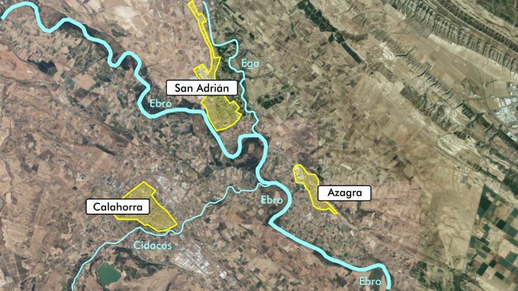
Within the scope of the Ebro Resilience Strategy, a total of 260 kilometers of the Ebro River are being studied, divided into 18 sections. Section 3 comprises the course of the Ebro river as it passes through the municipalities of San Adrián, Azagra (both in Navarra) and Calahorra (La Rioja), plus the last 5 km of the Ega riverbed before it flows into the Ebro river (Figure 1). The study focuses mainly on proposing solutions to reduce the risk of flooding in the urban areas of San Adrián and Azagra, considering that the urban center of Calahorra does not present flooding problems in terms of flooding from the Ebro or the Cidacos river, for floods with a return period of less than 100 years.
Since the solutions proposed for flood risk reduction in the town of San Adrián are independent and do not create synergies with those proposed for Azagra, it has been decided to fragment the study for its presentation, so that interested parties and the general public can focus their contributions, comments and suggestions on each of the towns that are the subject of the study.
This document presents the proposed solutions for flood risk reduction in the town of San Adrián (Navarra), which has been denominated as Section 3A.
BACKGROUND AND PROBLEMS DETECTED
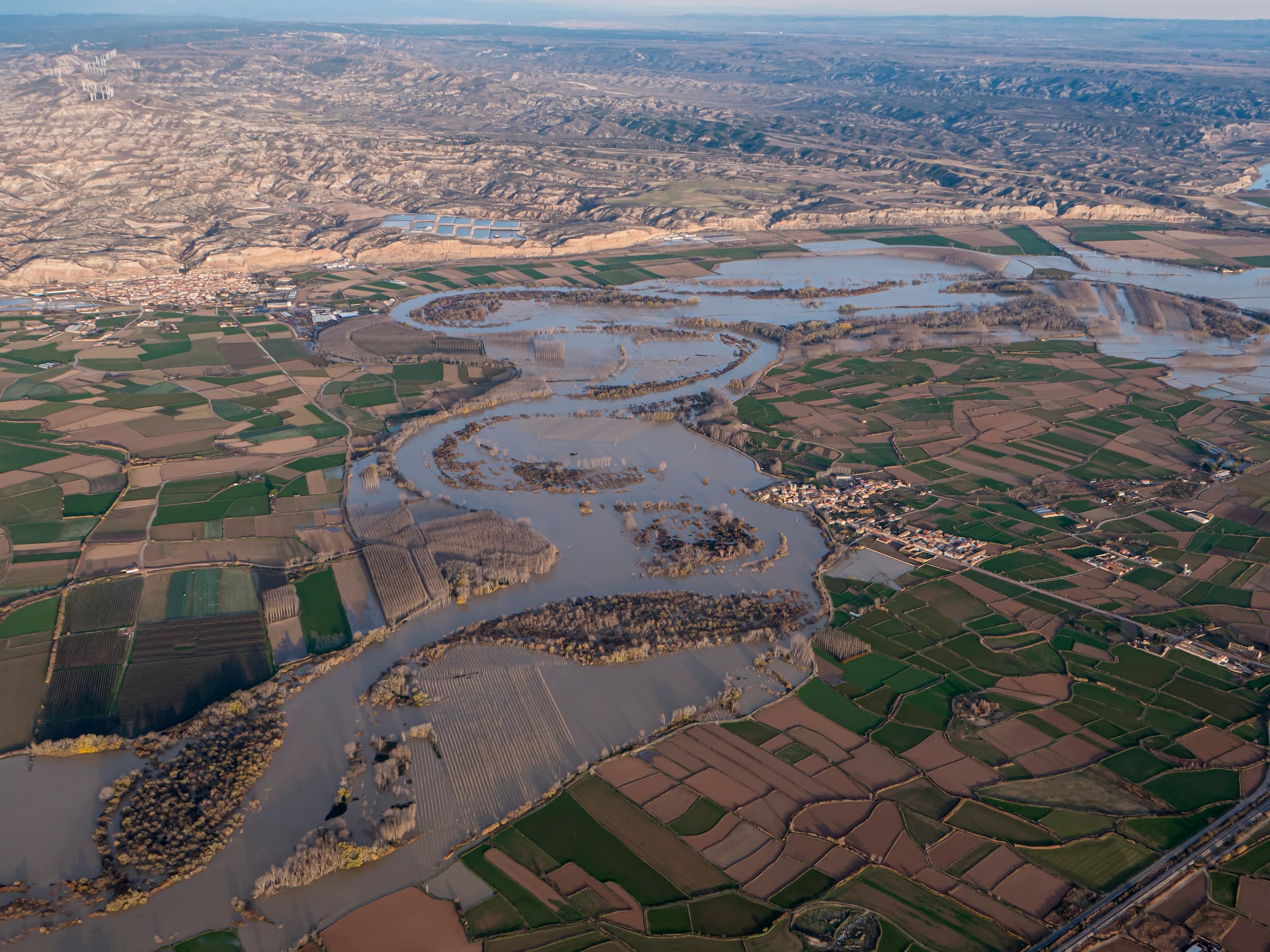
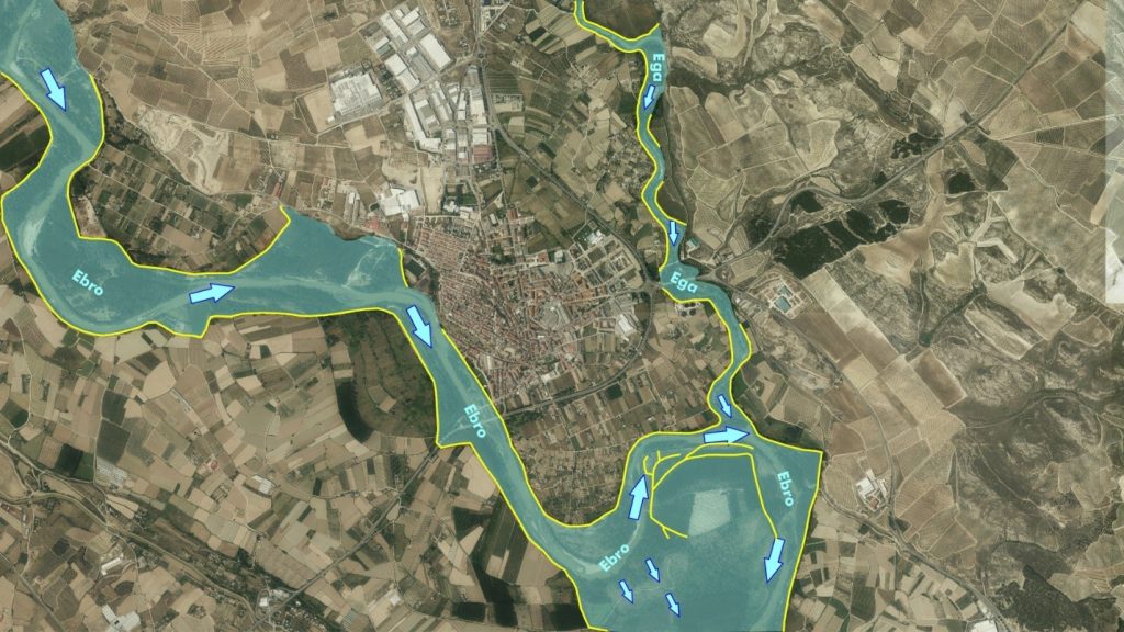
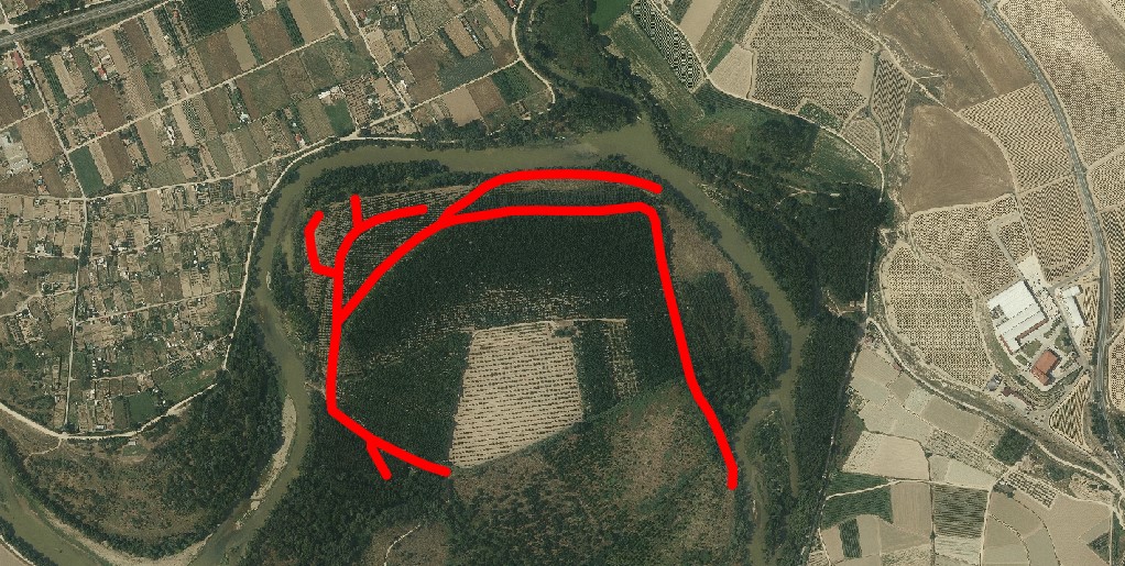
The town of San Adrián is located at the confluence of the Ebro and Ega rivers, on the left bank of the former and on the right bank of the latter (Figure 1). The historic center of the town is located on level four of the terraces [1] of the Ebro, at an approximate elevation of 315 meters above sea level [2]. This terrace was perforated by both channels, which converge at level five of the valley terraces, at an elevation of 292 meters above sea level, some twenty meters below the historic urban center.
In spite of being located in an area where the historical floods of both rivers must have left their mark in the popular memory, the city expands firstly on its eastern side (1945-1980), towards the fertile plain of the Ega River, overcoming the threshold of the Estella road. Subsequently and in a more prudent manner, since the 80s of the last century, the urban environment has grown on the south side towards the flood plain of the Ebro River (Figure 2).
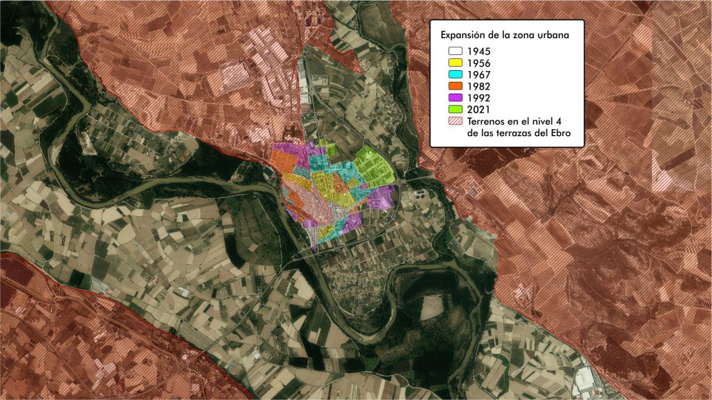
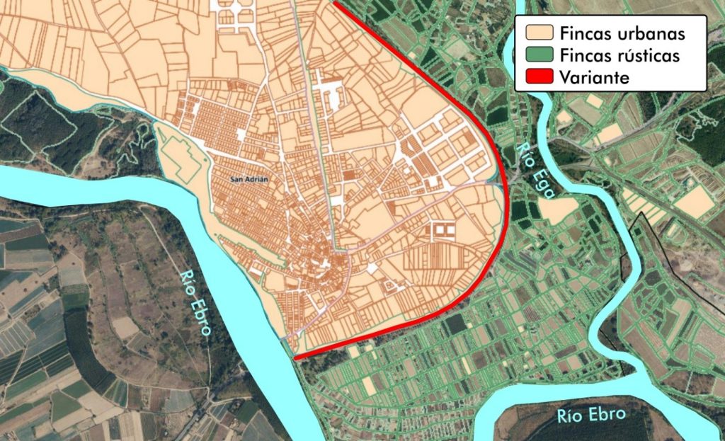
The construction of the bypass to the south of the town (NA-6531 road) in 1994 consolidated this expansion, so that all the land located between this bypass and the historic center is now classified as urban (Figure 3).
Despite the geographical location of the town, there are no historical references of major damage associated with floods in San Adrián, beyond the recurring damage caused by the flooding of the Ebro in the boat crossing between this town and Calahorra, whose approximate location is located in the place where the old bridge is positioned. [3] on the Ebro.
The growth of the urban area towards low-lying areas belonging to the floodplain [4] of the Ebro and Ega rivers (Figure 2) has increased the risk of flooding in the town. However, the construction of the bypass seemed to provide an insurmountable defense against flooding. When flood episodes are expected, the passages under the bypass are plugged with a clayey material of impermeable characteristics, forming a “wall” against the overflowing waters.
In the great floods of the present century, large extensions of land have been flooded, causing the breakage of the defense walls [5]. The major floods of 2003, 2015 and 2018 did not reach the area inside the bypass, beyond minor flooding due to rising water tables or due to transmission from ditches or poorly waterproofed collectors. In these episodes, although the overflow waters reached the bypass, they did not penetrate into the locality.
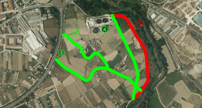
However, in the recent flood of December 2021, there has been a temporal and spatial concurrence of the peak floods of the Ebro and Ega rivers in their confluence zone. This fact caused the levels circulating in the Ebro River to prevent the Ega River from draining (① in Figure 4), whose flows were retained in its own channel, producing a rise in the height of the waters circulating in the Ega. The level reached by the waters overflowed the defense motes, producing several breakage points in them (② in figure 4). The overflowing waters accumulated against the embankments of the bypass and the NA-653 road, producing a reservoir that gradually increased in height, until it overtopped the bypass on its north side, at the junction with the Estella road (③ in figure 4).
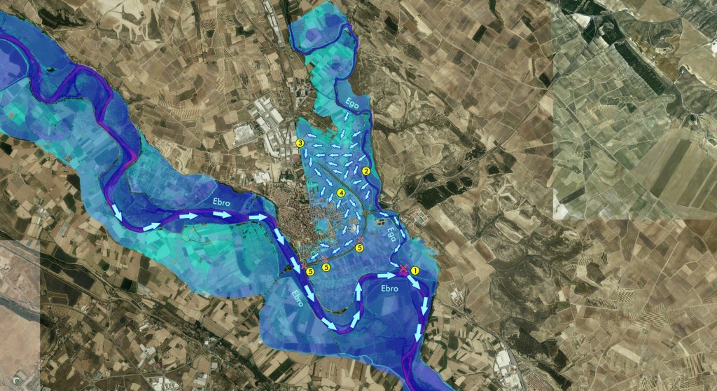
The waters that exceeded this point reached the urban area, moving towards the lower lands (④ in Figure 4). The existence of the bypass, with its clogged passages, prevented the overflowing waters from leaving the urban area (⑤ in Figure 4), increasing the residence time of the waters and, consequently, the damage. According to the testimonies collected after the flooding episode, it is likely that, additionally, there are old collectors that transmit the water levels circulating in the Ebro to the city’s sewage system, reducing the effectiveness of the measures carried out for the drainage of the water accumulated in the population.
ANALYSIS OF POSSIBLE CAUSES
Once the conditions detected have been exposed, it is necessary to study the possible causes of these problems, so that the intervention proposal resulting from this study focuses on the correction of the causes and not on their consequences.
For the preparation of the study, a series of technical studies have been carried out using the latest available technologies, which have made it possible to evaluate the current situation of the section with respect to the objectives set. Once the current situation has been evaluated, different alternatives for action have been studied, individually and in combination, selecting those that have produced the desired effects and discarding the less favorable or counterproductive ones.
Historical evolution
The Ebro and Ega rivers have undergone a gradual process of canalization in the study section. Although the construction of longitudinal defense dikes (also called motes or mazones) on both banks began with the appearance of large construction machinery in the 1960s, the generalized canalization of this section was completed between 1980 and 1984.
These dams are built, in most cases, with sediments from the river itself; consequently, their impermeability and consolidation is not optimal for the functionality for which they are intended. It is common for the fenders to leak through their bodies during floods and to be sensitive to abrupt moisture-dryness cycles. Due to their composition, the motes do not resist the overflowing of water by cresting, resulting in a sudden collapse of the structure in such cases. In addition, their location in a natural environment and their position on the banks of rivers means that they are colonized by vegetation and serve as shelter for animal species in the area, especially mammals, which can build their burrows and shelters in the defense lands, creating waterways and weak points.
When the defenses failed in flood episodes, they were repaired and, usually, raised in height, but rarely widened at their base. As a result, the levees have excessively vertical and unstable slopes. It is unquestionable that the channeling of the Ebro and Ega rivers has reduced the effective drainage sections of both watercourses and, as a result, for the same flow, the water must flow higher through the narrowing produced.
This circumstance, together with the weak points of the canalization mentioned in the preceding paragraphs, leads us to foresee that the damage caused by future floods will be greater than that caused by previous floods of similar flows.
Las canalizaciones del Ebro y del Ega no fueron construidas con criterios hidráulicos. The objective of its construction was to obtain the largest area of land available for cultivation. Both pipelines have very narrow areas combined with wider ones. In the narrow areas the waters over-elevate and the river deepens. In the wide sections, the water level is reduced and so is its flow speed, causing the deposit of excavated sediments in the narrow areas.
Digital Terrain Model (DTM)
One of the works carried out for the study is the elaboration of a digital terrain model [6] (called DTM) that reproduces the current situation. It is important that this DTM faithfully reproduces the conditioning factors of the river section under analysis, and for this purpose the work listed below has been carried out.
First, the terrain is reproduced on a large scale, using LIDAR topography [7], which consists of a scan of the terrain using aerial means (normally a light aircraft is used for large surfaces, but the use of drones is common).
Secondly, the topography of the most important elements for the study is obtained, such as: the crown of the dikes, walls, breakwaters, bridges, drains, etc. This work has been carried out using classical surveying methods, increasing the accuracy of the data in these key elements (Figure 6).
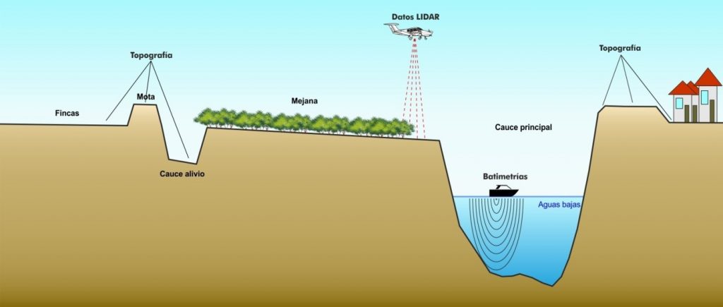
The above methods have the disadvantage that they are not able to obtain data from the ground beneath the water. This has been the main drawback encountered in previous flood studies. Technology is now available to obtain the topography of the river bed in a continuous manner.
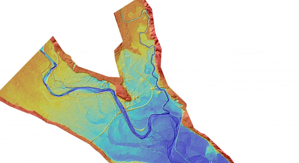
As a novelty for these studies carried out within the framework of the Ebro Resilience Strategy, aquatic means equipped with sonar [8] have been used for the collection of bathymetric data [9] of the riverbed, incorporating these data into the study. The data obtained are combined for the elaboration of the DTM (Figure 7).
The DTM analysis has corroborated the circumstances observed during the 2021 flood. The variant has encompassed low-lying land in its interior, which is where the overflowing waters that manage to penetrate the internal enclosure of this infrastructure are directed.
On the other hand, the connection of the bypass with the NA-134 road is made by means of a bridge over the Ega river with associated embankments on both abutments. The combination of the bridge, the embankments and the Lower Ega WWTP, located immediately downstream of the bridge and at a very high elevation, represent a barrier to the Ega’s floods, as they interrupt its effective flood plain.
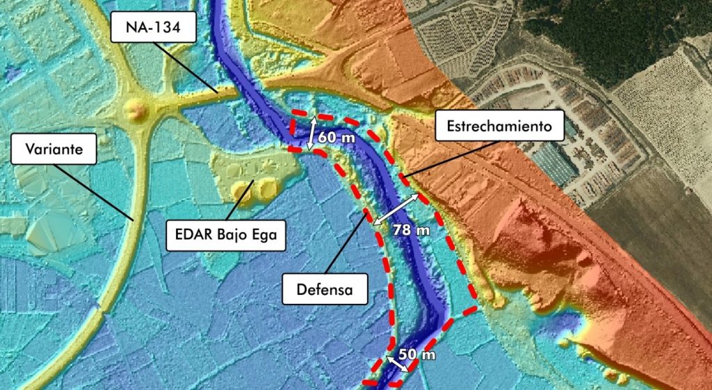
Immediately downstream of these bridges, the canalization forms a very narrow section in the Ega River. The effective drainage width is limited to a minimum of 50 meters in the narrowest areas (Figure 8).
Hydraulic model
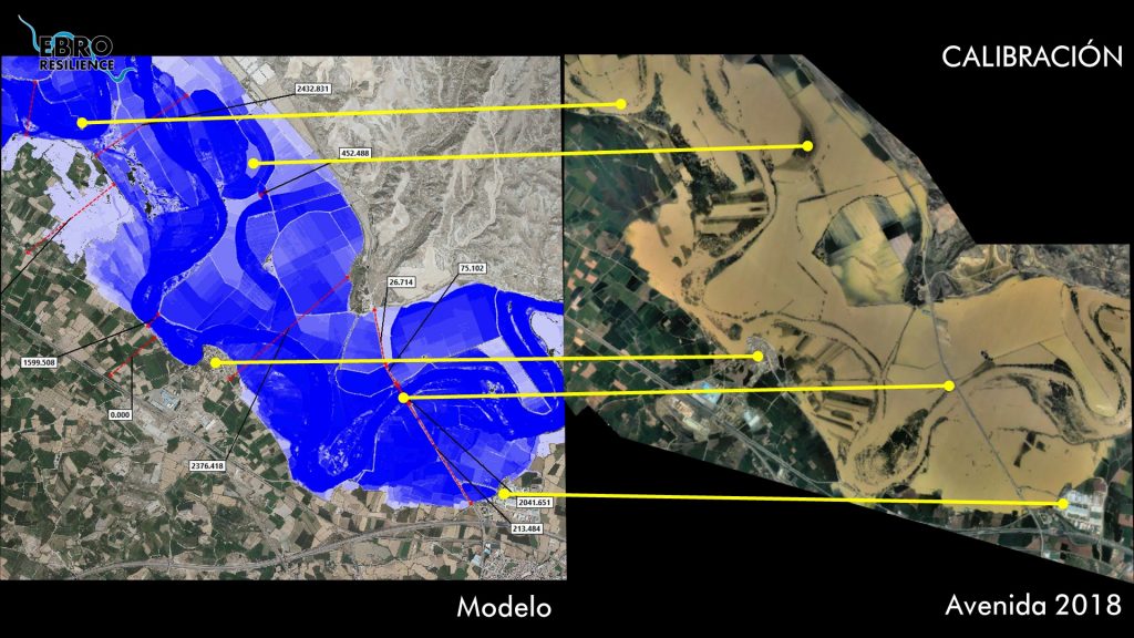
The next step of the study is the analysis of flooding episodes. Hydraulic models are used for this work, which consist of a computer tool that applies a given flow rate to the DTM and reproduces the effects of flooding.
These computer tools require a process called calibration to adjust the results obtained to the characteristics of the section under study. In this case, the aerial photos of the avenue from April 2018 and December 2019 were used, achieving a good calibration.
Once the hydraulic model has been configured and calibrated, the target flood is reproduced and the effects on urban areas are analyzed.
With respect to the problems that may be caused by possible overflows, it should be borne in mind that the hydraulic model considers the terrain to be rigid, i.e., the motes do not collapse at any time, even if they are overflowed. To compensate for this circumstance, the flood peak in the simulation will be prolonged in time, achieving flooding effects similar to those produced in a real event.
The result of the modeling is discussed in section 5 “Study of Alternatives”.
STUDY OBJECTIVES
In accordance with the Ebro Resilience Strategy, the specific objectives of the study were as follows:
- Evaluate the level of protection of the urban area of San Adrián for floods with a return period of 25 years, which corresponds in this section to a flow of 2,000 m3/s in the Ebro river and 350 m3/s in the Ega river.
- Propose actions to prevent flooding, in the event of flooding.
- Reduce damage in non-urban areas for a 10-year return period flood, which in this section is equivalent to a flow of 1,780 m3/s in the Ebro river and 300 m3/s in the Ega river.
With respect to the above-mentioned flows, it should be borne in mind that the combination of possible flows that can occur simultaneously in the Ebro and the Ega is practically infinite. However, in the study carried out, the floods of the same return period have been made to coincide in order to consider the worst combination in each scenario.
The study has a pre-project level, being determined to select the most suitable alternatives and to allow the environmental evaluation of the proposed solutions. The definition of the exact dimensions of the actions to be carried out and their details must be included in the corresponding construction project.
STUDY OF ALTERNATIVES
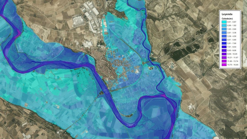
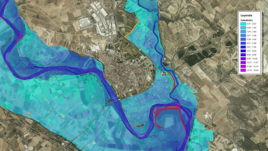
In the analysis of the simulation of the target flood for a return period of 25 years in both rivers, it can be observed that the flood produced would be greater than that of December 2021, although the flooding process would be similar.
The hydraulic model generates a plan with the flooded areas at the maximum moment of the flood. This plan shows, with different colors, the depth reached by the water during flooding (Figure 10).
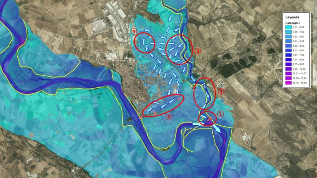
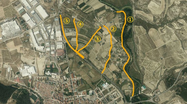
The Ega River would be plugged by the Ebro River in its confluence zone and dammed in its own channel (① in Figure 11). This phenomenon would be aggravated by the aforementioned narrowing existing in the channel immediately upstream of its mouth (② in Figure 11). The channel would be overtopped by the flood (③ in Figure 11) and the bypass would lead the overflowed waters towards the Estella road, being overflowed in its northern section (④ in Figure 11). Water overtopping the bypass would end up flooding the lower areas of the urban area and would accumulate next to the southern section of the bypass, with no possibility of return to the river (⑤ in Figure 11).
Taking into account these five areas of interest, alternative actions will be sought to solve or mitigate the problems described. These actions must also function correctly together and, for floods with a return period greater than those considered in the study, not create greater problems than those that would have existed if no intervention had been made.
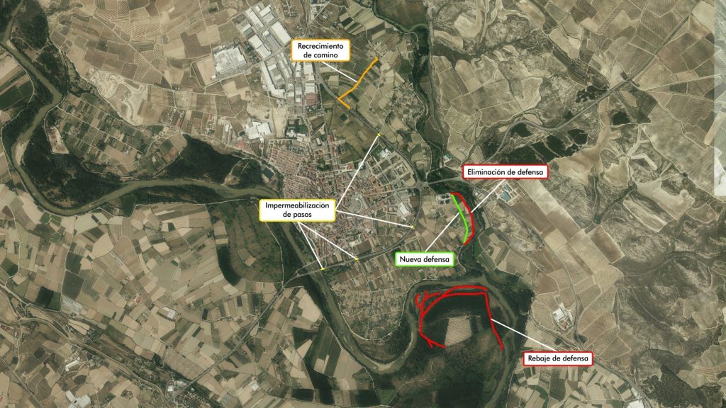
Alternatives in the confluence zone
In the area of confluence with the Ega (① in Figure 11), the Ebro River draws a wide meander on the right bank, called La Concha. For major floods, the river should cut the meander, reclaiming its floodplain and reducing the level of water flowing through the main channel.
The Concha meander has two dykes to defend against flooding. A first line mote, 1 meter high, and a second line mote with an approximate height of 2 meters. These levees are configured to allow flooding of the land from downstream, so that when the water overflows the levee, the farm is pre-flooded to reduce damage to the land and protect crops and infrastructure. That is, it functions as a floodable area.
These motes force an important part of the water flowing through the Ebro River to go around the perimeter of the meander, concentrating the flow at the confluence of both rivers and favoring the clogging of the Ega River.
To this end, it is proposed to lower or eliminate the existing dips in the meander, so that the waters can overflow to the right bank at a lower height and facilitate the joint drainage of the Ebro and Ega.
Other options have been considered, such as dredging the riverbed, removing sediments and widening the section by lowering the riverbed. However, this solution is not advisable. The bathymetry shows that in the confluence zone a 4-meter deep pool has been created, possibly caused by the strong narrowing caused by the channelization. The deepening of this pool could lead to a process of upward erosion. [10] in both watercourses, similar to that suffered in other watercourses such as the Arga. Consequently, the increase in section must occur in the form of width.
Alternatives in the area of the narrowing of the Ega River
In this area (② in Figure 11) it is necessary to increase the drainage section to reduce the funnel effect caused by the narrowing of the channel. Taking into account that the land on the left bank is located at a higher elevation than the land on the right bank, it is more efficient to set back the left bank mound, moving it away towards the interior of the bank.
Several alternatives for the dike setback have been studied (Figure 13). The objective is to optimize the drainage capacity of the section with the least possible occupation of marginal lands and without affecting the Bajo Ega WWTP, being alternative ④ (Figure 13) the one that meets these requirements.
Alternatives to avoid the overflow of water over the variant
In the section of the Ega River upstream of the urban area (③ and ④ in Figure 11), there is an overflow over the defense dike that causes it to break at several points. The overflowing waters end up entering the urban area.
To avoid this circumstance, it is necessary to intercept the overflowing water, preventing it from reaching the urban area, but without creating other areas where the water can accumulate and reach a greater height, which could lead to unforeseen overflows. The apparently simplest alternative would be to raise the existing seawall. Approximately 160 m3/s can flow through the current pipeline. In order for the 25-year return period flood, with a flow of 350 m3/s, to flow through the channel without causing overflows, it would be necessary to double the current drainage section. This would require tripling the height of the current dyke.
defense, going from the current 2 meters to about 6 meters. This intervention would be very dangerous, since any failure in the dam would introduce overflowing flows with a height of six meters on the lands of the margin. In addition, the infrastructure must be safe to visit during flood episodes, to allow monitoring of the water level and overflow protection. In this sense, it does not seem very advisable to carry out inspections on a six-meter-high levee saturated with water during the passage of a flood.
Having ruled out the possibility of raising the levee, four alternatives of possible interception infrastructures have been studied using existing roads. The most efficient is the one indicated as ③ in Figure 14, as it rests on higher ground, which limits the height of the defense and guarantees its stability and safe accessibility in flood episodes.
Alternatives to prevent water accumulation in the urban area
Although the proposed actions would prevent flooding of the urban area for floods with a return period of 25 years, the possibility of floods with higher flows or even the failure of some of the existing or planned defense infrastructures cannot be ruled out, so that the overflowing waters would once again reach the urban area.
In this case, it is necessary to provide elements that allow the evacuation of the water through the passes under the bypass at the same time that the levels in the riverbeds are lowered, thus reducing as much as possible the time that the water remains in the locality.
It is proposed to design closing gates in all the passages under the bypass, so that the gates close against the thrust of the water inflow through the bypass and open against the thrust from inside the urban area.
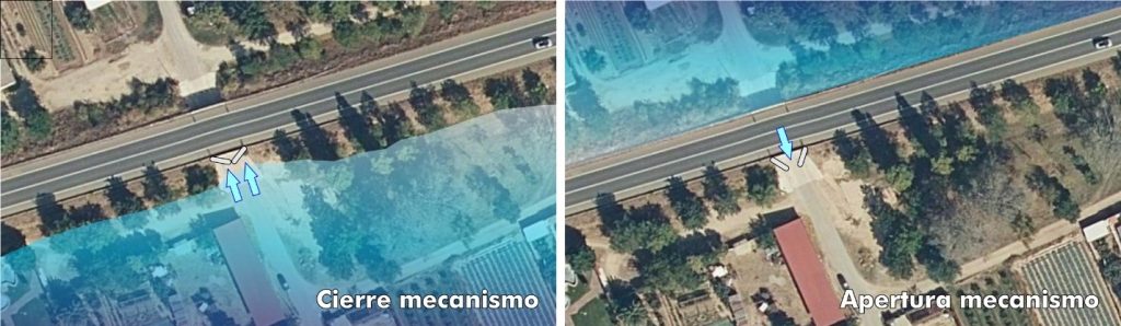
In addition, these mechanisms will allow a longer reaction time in flood episodes and a faster return to normality.
Description of the proposed alternative
The alternative that has been shown to be the most efficient in the simulations and that meets the established conditions is a combination of the different actions mentioned in the previous paragraphs.
The hydraulic simulation shows that the objectives are met, the urban area would not be flooded and the water level would be reduced in 160 ha of agricultural land (Figure 17) for a 10-year return period flood.
CONCLUSION
The alternative selected as the most efficient would prevent flooding of the urban center of San Adrián for floods with a return period of 25 years, achieving the objectives initially proposed.
The study has a pre-project level, being determined to select the most suitable alternatives and to allow the environmental evaluation of the proposed solutions. The definition of the exact dimensions of the actions to be carried out and their details must be included in the corresponding construction project.
The execution of these actions must be associated with a follow-up of their evolution that will make it possible to verify that the objectives pursued are achieved.
WHAT NOW?
Once the detailed study of the section has been completed, participatory meetings open to the public will be held to ascertain the opinion of the population.
The corresponding adjustments will then be made to the proposal, if necessary, and the environmental processing of the interventions will begin.
Finally, the construction projects will be drawn up and each Administration will implement, within the scope of its competences, the actions for a better management of the flood risk of the corresponding section.
[1] The Ebro River has formed five terrace levels through the erosion of its valley, with level one being the oldest and located at the highest altitude and level five being the deepest and the one that is currently morphologically active.
[2] Meters above sea level in Alicante, reference point, or zero elevation, of the topographic heights in Spain.
[3] La barca de San Adrián: del vado al puente, dos mil años de noticias en la muga del Ebro (Allo J., 2017).
[4] Land that floods with a minimum probability of occurrence of once every 500 years.
[5] Longitudinal flood defense dykes, parallel to the river axis and generally formed with sediments extracted from the riverbed itself.
[6] The equivalent of a terrain model, but in a digital environment.
[7] Acronym for Light Detection and Ranging or Laser Imaging Detection and Ranging.
[8] An element that obtains the depth of the bottom of the sea or a river by emitting sounds and measuring their reflection.
[9] Topography performed underwater.
[10] The process by which erosion of a river bed advances upstream.