
One of the lines of action of the LIFE Ebro Resilience P1 Project is the improvement of social capacities, in fact, it has a specific Plan, defining 16 campaigns of actions for different sectors of the population .
The objective is to increase shared knowledge about rivers and floods, foster networking among the riparian population and facilitate common tools to become more resilient.
Having a reference glossary to use the same terms and understand them, is a step in that direction and therefore, we launch here some of those terms arranged in three categories: the river, floods and Ebro Resilience terms.
In addition, we invite you to visit this link also of the LIFE Ebro Resilience P1 Project with other common terms when dealing with the extreme phenomena of floods and droughts.
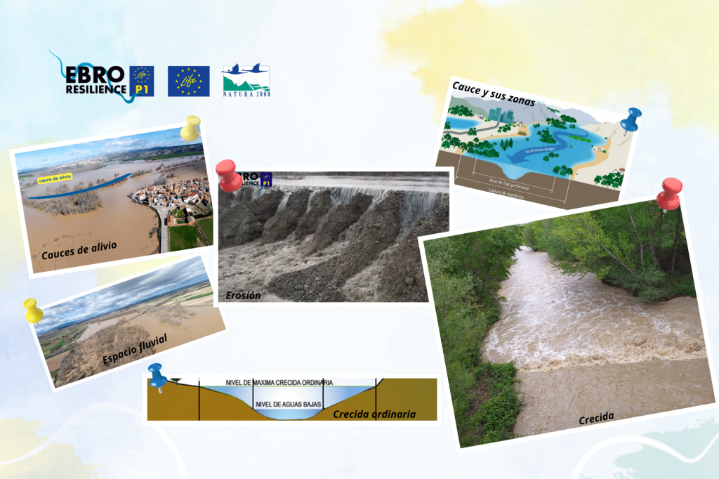
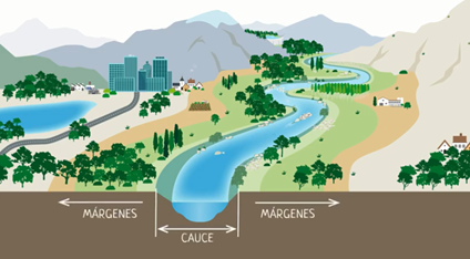
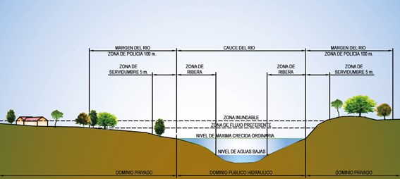
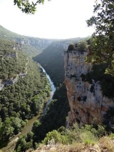
Cauce
Land occupied by water at the maximum ordinary flood. It is also called alveo or natural channel. It is applied both in permanent currents in time (rivers) and in temporary ones (ravines or streams). It is formed from surface runoff. It is not only the area of the river through which the water flows (which is called the low water course), but also includes the land covered by the water during ordinary floods. The banks are part of the riverbed and therefore belong to everyone, they are Public Hydraulic Domain.
Natural watercourse: watercourse.
Low-water or low water course: land occupied by the waters of a river during the driest period of the year.
Flow rate
Volume of water flowing through a section in a unit of time. In large quantities (rivers) the cubic meters passing through a section in one second (m3/s) are measured. When the quantities are small (ditches, pipes, streams), the number of liters passing through a section in one second (l/s) is measured.
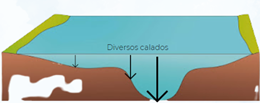
Fretwork
The height that the water reaches at a given time and place. Along the course of the river course it varies continuously, as the height of the riverbed is diverse.
Public Hydraulic Domain (DPH)
This is the area occupied by the watercourse and the water it carries, together with related elements(aquifers, reservoir beds, desalinated water, etc.).
Specifically, it includes inland waters, both surface waters and groundwaters and also those resulting from desalination; the beds of natural, continuous or discontinuous streams and the beds of lakes and lagoons and those of reservoirs.
Galacho
This term defines an old river branch that is disconnected from the riverbed from upstream and held together from downstream. In floods it can resume normal operation.
Hydrology
Science that studies the water cycle and its behavior on Earth.
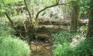
Bed
Land that is submerged in a watercourse, lake, lagoon or reservoir.
Margins
Land contiguous to the riverbed. Of a private nature. Looking downstream, the left bank is the one that would be on that hand and the right bank is the one that would be on the other hand.
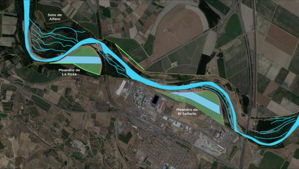
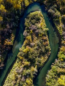
Meander
Curve drawn by a river in its course. They usually occur in valleys with a gentle slope, such as that of the Ebro. Meanders are not stable over time and can change shape, disappear or form new ones.
Mejana
Term used locally in the province of Zaragoza to refer to the large islands that form in a river.
Shores
Area of the riverbed bordering the water.
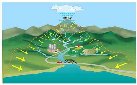
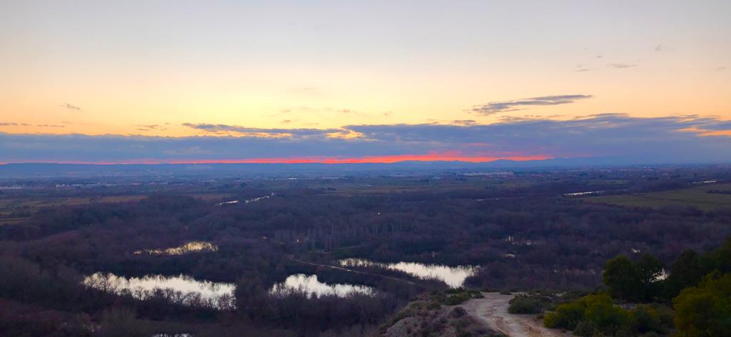
River
They are freshwater streams that are formed thanks to the water from rain, springs, ice and snow. It is a continuous stream, in continuous movement and in constant change, both in its content and in its morphology.
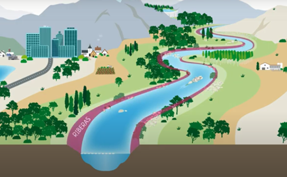
Riberas:
Lateral strips that can be found above the low water level and below the submerged land during the maximum ordinary flood.
Therefore, they are part of the watercourse, are integrated in the Public Hydraulic Domain and belong to everyone.
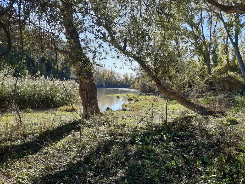
Soto
Forest that forms on the banks of a river. Sotos, mejanas, meanders, galachos, river mothers, are part of the fluvial dynamics of the Ebro river, they are witnesses of the great floods and in fact, they are the effect of the natural deposits of the river.
The groves are part of the floodplain and participate in the work of “holding” the river. They are also a refuge for flora and fauna.
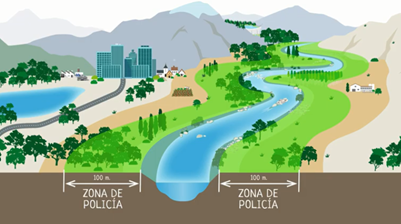
Police zone
It is the strip of 100 meters on each side of the limit of the channel. It is not Public Hydraulic Domain (*see definition), but it can be flooded during floods, so any alteration of its relief or construction must be authorized in advance by the managing body.
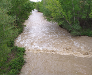
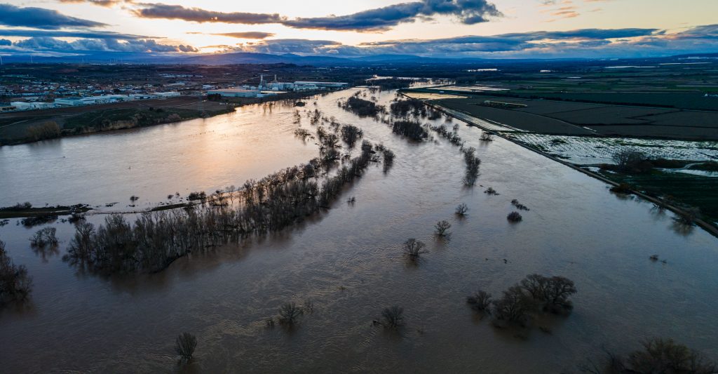
Avenue/ Flood
Unusual increase in water flow in a watercourse that may or may not cause overflows and floods.
Maximum ordinary flood
A flood in the course of a river that is defined by providing a flow that completely occupies the section of the riverbed (*see definition).
Extraordinary flood
It is the flood that overflows the limits of the channel and exceeds the flow of the maximum ordinary flood.
Drainage capacity
Maximum flow that a section can drain before overflowing. It can be reduced by the presence of blockages (which are usually generated after flood episodes).
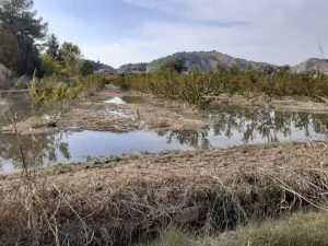
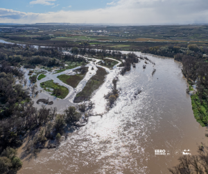
Flooding
Temporary flooding of land not normally covered by water caused by the overflowing of rivers, mountain torrents and other continuous or intermittent water currents, as well as by the sea in coastal areas and those produced by the joint action of rivers and the sea in transition zones.
Return period
The frequency with which an extreme event occurs. For example, a 100-year return period flood means that, on average, an event of that magnitude is expected to occur once every 100 years.
Flood Risk Management Plan (PGRI)
Reference document in each river basin for the management of river floods and coastal storms. It gathers the measures of all the Administrations that have competences related to flood management and also actions for the society in general.
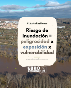
Flood risk
Flood risk is defined as the potential for damage to people, property or services as a result of flooding. The level of flood risk is the combination of three components: HAZARD x EXPOSURE x VULNERABILITY.
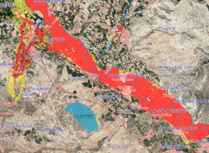
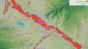
Flood zone
Area of land that may be temporarily flooded by water due to the overflowing of rivers, torrents, heavy rains or coastal phenomena. Its cartographic delimitation is based on hydrological and hydraulic studies that consider historical facts, return periods, official cartography…
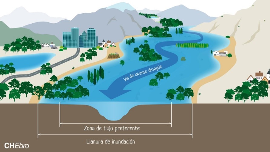
Preferential flow zone
That zone constituted by the junction of the zone or zones where the flow is preferentially concentrated during floods, or intense drainage way, and the zone where, for the 100-year return period flood, damage to people and property may occur.
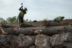
Bioengineering
Technical discipline that uses living plant elements as construction materials. It is used to stabilize slopes and riverbanks, reduce erosion and regenerate riverbanks.
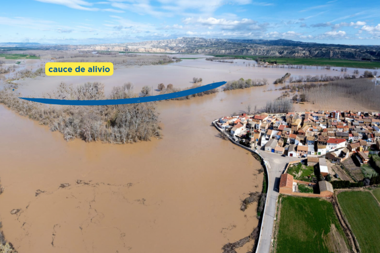
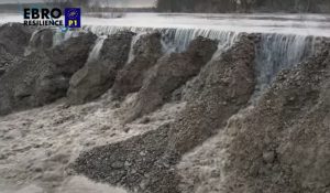
Relief channel
New branches of the river that are created and come into operation during floods. They can be artificial branches, excavated in the ground, or partially natural, when they connect with old branches of the river that have lost their functionality.
The relief channel is excavated at a higher level than the riverbed, so that when the water level rises, it flows through the two available routes.
This intervention increases the width of the river when needed (during floods), reducing the height of the flowing water.
It also allows water to be directed to areas of interest, to reduce the pressure on the longitudinal protections of urban centers or to favor the functionality of bridges.
River dynamics
Set of changes that the riverbed undergoes naturally in its forms (bed, banks, sediment, topography, course, etc.). River dynamics is mainly induced by the water flowing through the river (major floods increase it, the regulation of a river decreases it), although geological (composition of the terrain) and biological (vegetation) elements also have an influence.
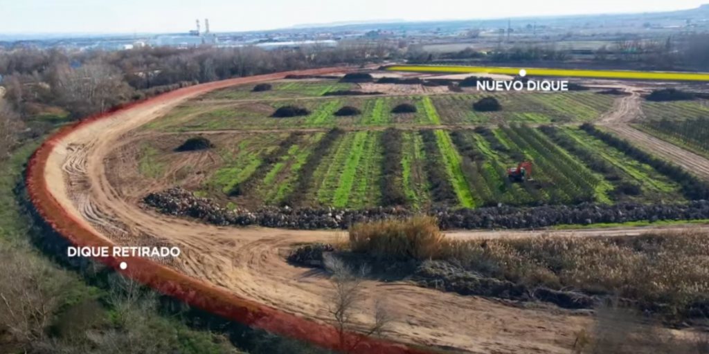
Dam
An artificial element constructed to carry water. In a river they are usually parallel to the direction of the current and are built on the banks to try to delay the moment of overflow. In the Ebro, they are generally built with sediments extracted from the riverbed itself and are locally called “mazones” in La Rioja and “motas” in Navarra and Aragón.
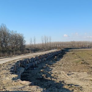
Breakwater
Large stone used for the reinforcement of dikes, breakwaters, banks or other elements. The reinforcement with breakwaters hinders the growth of vegetation and increases the speed of water flow by exerting less friction on the passage of the current.
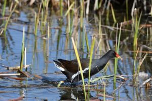
River ecosystem
Set of living beings (flora and fauna) that develop depending on a river, including the subsoil. In an arid environment such as the Ebro valley, there are species that depend on the river to live, but that do not live in the riverbed itself (birds of prey, mammals).
Erosion (effect)
A process in which soil is lost. In a river it usually occurs on the banks or bed of the riverbed.
River space
Scientific concept that includes the riverbed and surrounding land (even if privately owned) necessary for the river to develop a natural fluvial dynamic and not restricted by human action. It is also called river territory.
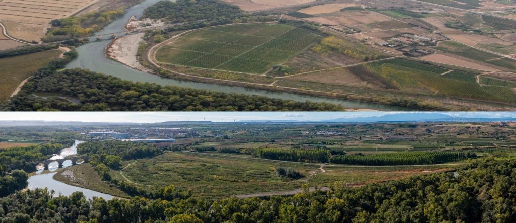
Old mother
A former riverbed or meander that the river has abandoned due to changes in its course, becoming over time an independent body of water or a dry riverbed.
The recovery of abandoned watercourses, or the reconnection of meandering watercourses is an Ebro Resilience action to improve river dynamics.
Nature Based Solutions: (SbN)
Actions that protect, sustainably manage and restore natural or modified ecosystems to address social, economic and environmental challenges. They rely on the power of ecosystems to solve problems, as opposed to “gray” solutions that rely on artificial infrastructures and technologies. They also promote the conservation and well-being of nature.
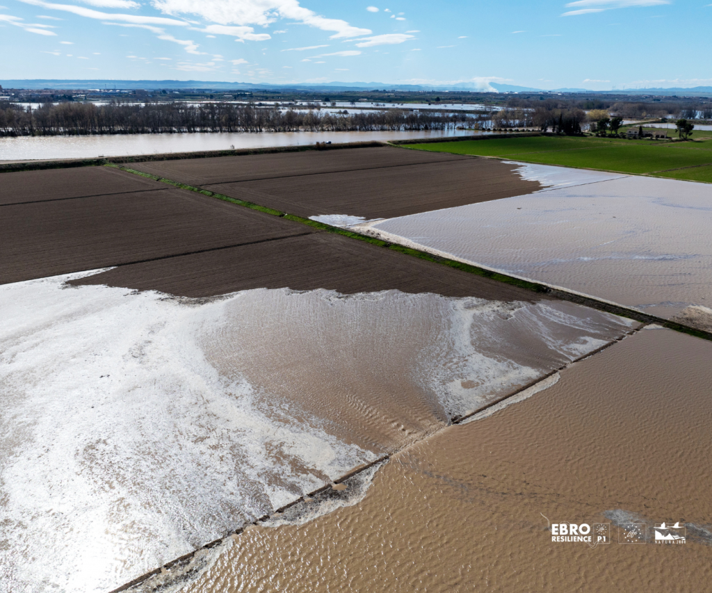
Lateral Flow Buffer Zones
Temporary flooding areas, arranged as a succession of cells in arable areas. They are pre-flooded in a controlled manner before the generalized overflow that occurs during floods, creating “water cushions” to minimize damage to farms and infrastructure, mainly irrigation.
The water is prevented from flooding the fields without control, reducing erosion and the impact on infrastructures. The water enters beforehand without the force and speed that the flow in the river does reach, and when the episode arrives, it does so over a cushion of water.
LIFE Project
The LIFE Ebro Resilience P1 Project (LIFE20 ENV/ES/00327), approved by the European Commission in the LIFE 2020 call, covers three autonomous communities (La Rioja, Navarra and Aragón), has a duration of 6 years and a total budget of 13,310,350 €, with 55% European funding.
This project is also an example of institutional coordination and cooperation in the intervention section, its partners being the Ministry for Ecological Transition and Demographic Challenge (MITECO), through its companies TRAGSA and TRAGSATEC; the Ebro Hydrographic Confederation; the Government of La Rioja; the Government of Navarra, through Gestión Ambiental de Navarra, S.A. (GAN-NIK); the Government of Aragón and the Aragonese Water Institute.
.
LIFE Project
The LIFE Ebro Resilience P1 Project (LIFE20 ENV/ES/00327), approved by the European Commission in the LIFE 2020 call, covers three autonomous communities (La Rioja, Navarra and Aragón), has a duration of 6 years and a total budget of 13,310,350 €, with 55% European funding.
This project is also an example of institutional coordination and cooperation in the intervention section, its partners being the Ministry for Ecological Transition and Demographic Challenge (MITECO), through its companies TRAGSA and TRAGSATEC; the Ebro Hydrographic Confederation; the Government of La Rioja; the Government of Navarra, through Gestión Ambiental de Navarra, S.A. (GAN-NIK); the Government of Aragón and the Aragonese Water Institute.