Download Detail Study – Stretch 5 (PDF)
BACKGROUND AND PROBLEMS DETECTED
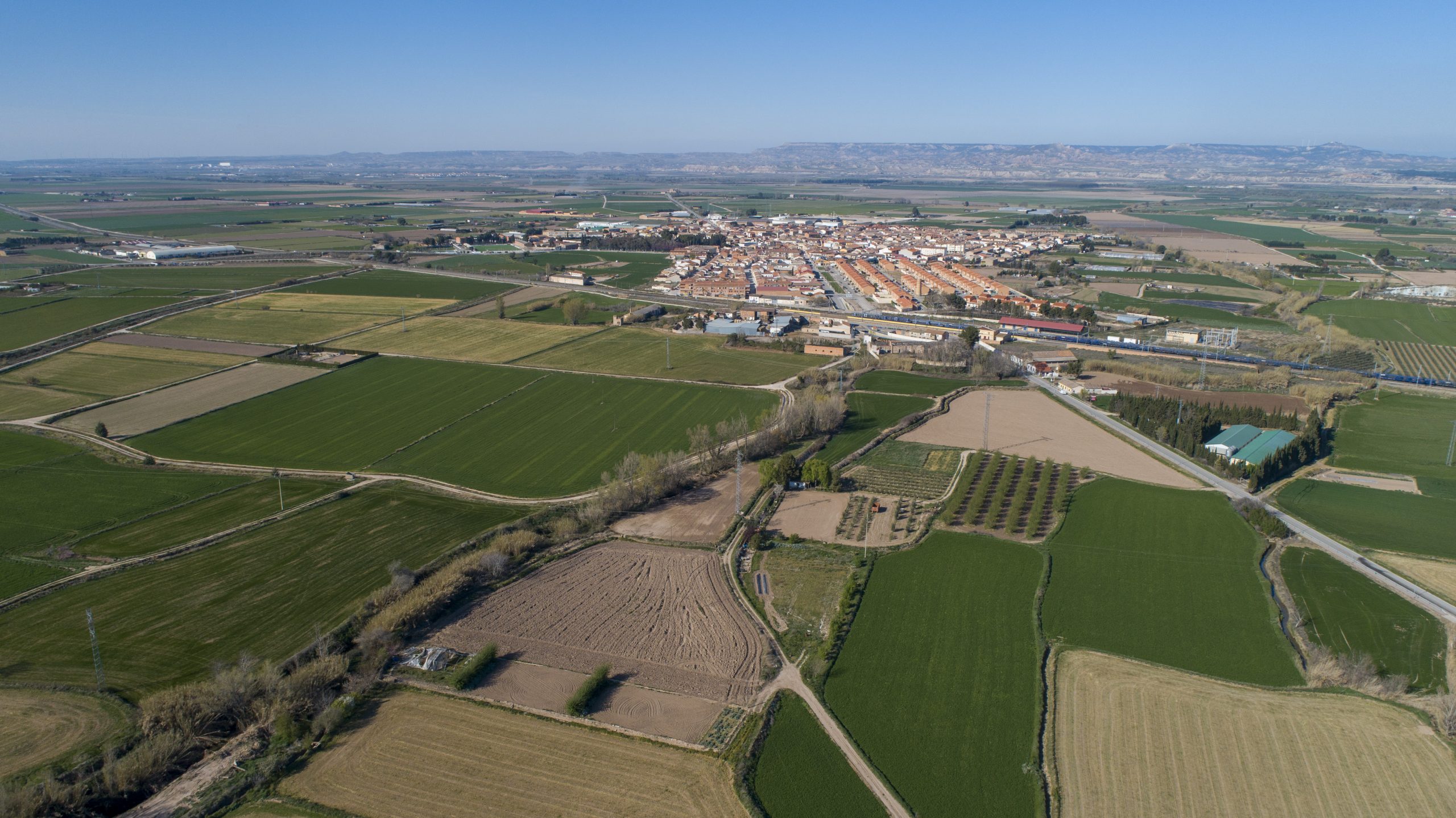
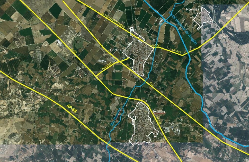
Within the scope of the Ebro Resilience Strategy, a total of 260 kilometers of the Ebro River are being studied, divided into 16 sections. Section 5 comprises the course of the Huecha River as it passes through the municipalities of Mallén, Cortes and Novillas, with a section length of 9 kilometers (Figure 1).
Throughout history there have been multiple episodes of flooding caused by the Huecha River. The historical references found are as follows:
- Year 1555 – 1556. In those years, the Huecha River flooded in the Borja area, destroying the construction of the Balseta vault, which had begun on February 14, 1555.
- June 29, 1871. On this date, due to the flooding of the Huecha River, the town of Agón was flooded up to a height of approximately 1.90 meters, according to the measurement made on tiles located on the wall of a house. There was also damage to agriculture.
- August 1892. During the month of August, the Huecha River overflowed its banks, affecting the town of Ambel.
- September 1892. During the month of September the Huecha River had a strong flood that affected the town of Magallón.
- May 3, 1910. On the aforementioned date, the Huecha River registered a strong flood that seriously affected the town of Agón. The town was flooded under 2 meters of water, the road was cut off and many houses were destroyed, killing one person and numerous domestic animals. Another locality that was badly affected by the flood was Mallén, where many houses and most of the fields were flooded.
- Year 1934 – 1935. Although the date has not been able to be obtained with greater accuracy it is known that the flood that had the Huecha between the years 1.934 -1.935 ruined the bridge of the road of the town of Mallén, perishing a woman who was on it.
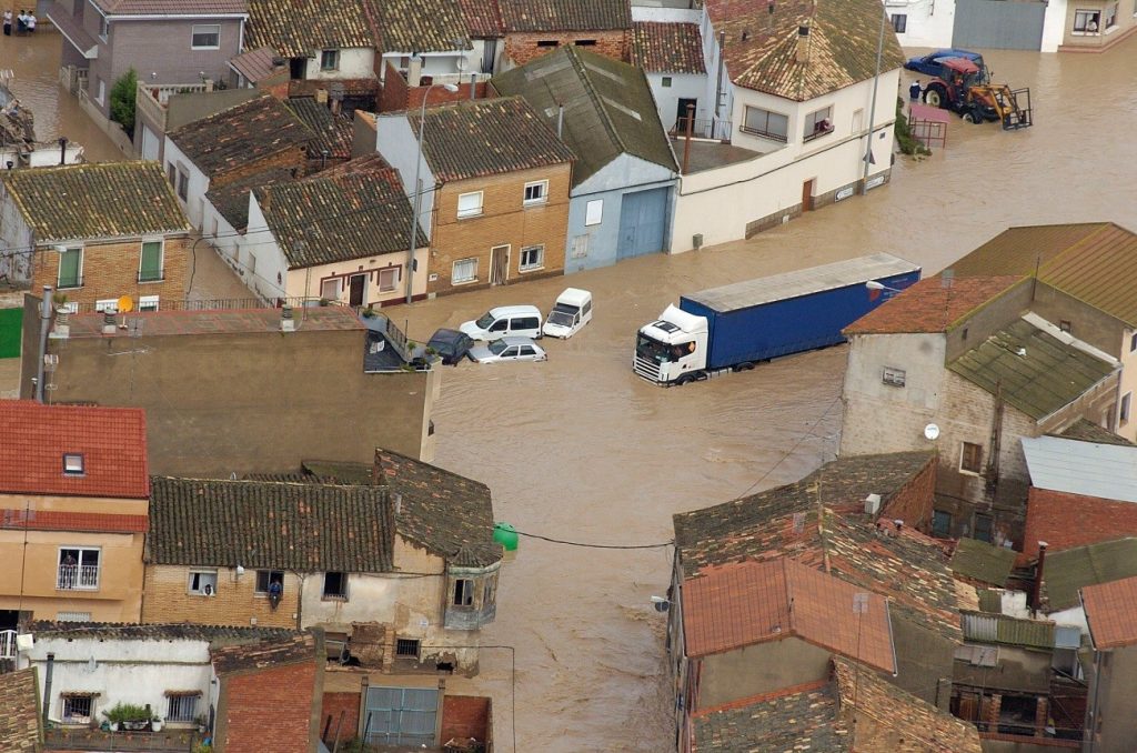
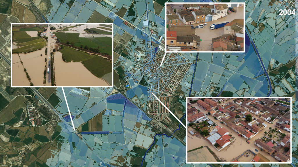
- In September 2004, more recently there was a major flooding of the Huecha river, which caused significant flooding in the towns of Mallén, Cortes and Novillas.
The 2004 flood, the most recent and for which data and graphic documents are available that allow us to determine the damage suffered, shows a shallow but very extensive flood. Between September 6 and 7, 2004, a large squall dumped heavy rainfall in the middle basin of the Ebro River. This storm passed through the communities of Navarra, La Rioja and Aragón, affecting the basins of the Yalde, Mayor, Arba, Queiles, Huecha and Jalón rivers and numerous ravines on both banks of the Ebro River between the provinces of Navarra and Zaragoza, causing large runoffs that exceeded the hydraulic capacity of the riverbeds, causing significant flooding and the subsequent overflowing of the rivers.
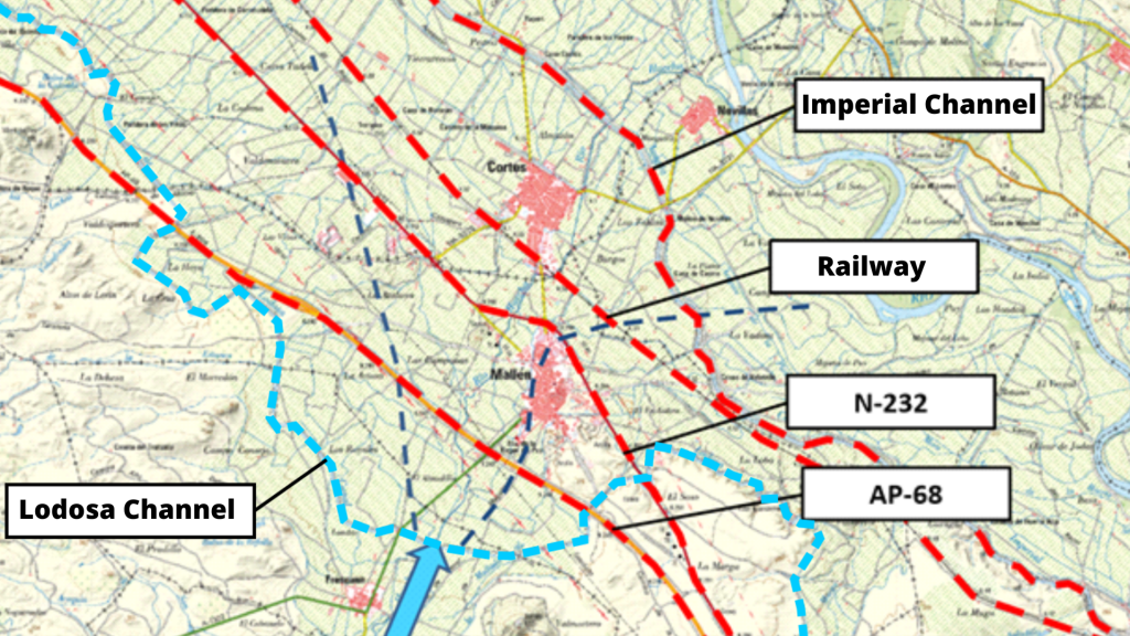
In this episode, the most affected population was Cortes. A failure of the railroad embankment caused the flooding of a large part of the urban area (Figure 2).
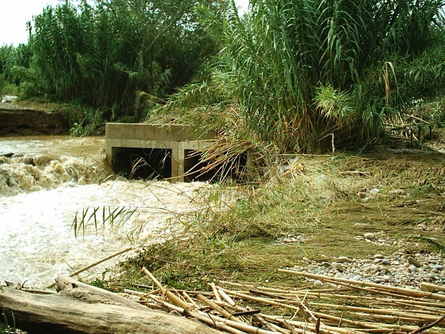
In Novillas, the waters also reached the urban area and the river washed away the “El gato” bridge, which provides access to the cultivated area on the right bank of the Ebro (Figure 3).
The waters of the Huecha and other ravines reached the Canal Imperial de Aragón, which was damaged on its banks and served as a propagator of the flood, transferring the waters to the districts of Boquiñeni and Luceni (Zaragoza).
ANALYSIS OF POSSIBLE CAUSES
Once the conditions detected have been exposed, it is necessary to study the possible causes of these problems, so that the intervention proposal resulting from this study focuses on the correction of the causes and not on their consequences. For the preparation of the study, a series of technical studies have been carried out using the latest available technologies, which have made it possible to evaluate the current situation of the section with respect to the objectives set. Once the current situation has been evaluated, different alternatives for action have been studied, individually and in combination, selecting those that have produced the desired effects and discarding the less favorable or counterproductive ones.
Geomorphological analysis
The Huecha river rises in the foothills of the Moncayo, an area that is often affected by stormy phenomena. These are generally convective phenomena[1] that are difficult to predict and produce significant precipitation in a short period of time in localized areas. Due to the configuration of the basin, this type of precipitation causes torrential floods[2] with sudden increases in flow, which reduces the response capacity.
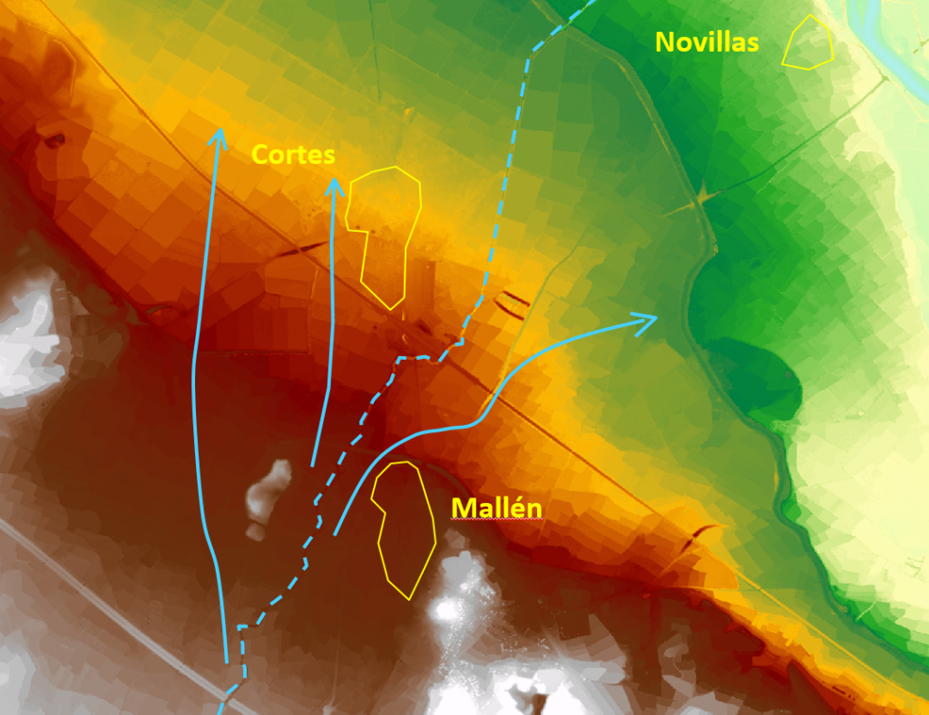
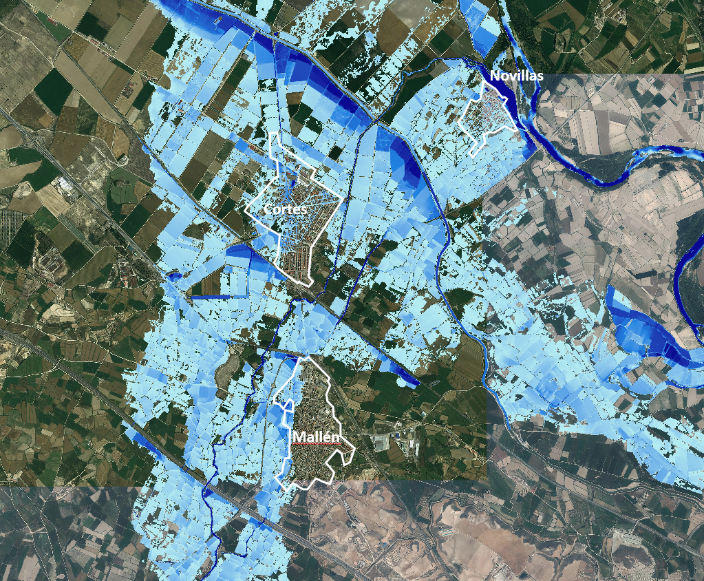
Downstream of Fréscano, the Huecha river comes into contact with the alluvial plain[3] of the Ebro river. This sudden change in slope over the centuries has caused the sediments of the Huecha River to fan out over this plain in what is known as a “cone of dejection”. This topography conditions the way in which the Huecha River floods when floods occur.
Once the Huecha River reaches the alluvial plain of the Ebro River, the waters overflowed during a flood are distributed along the fan without the possibility of returning to the riverbed (Figure 4). This is a natural phenomenon that occurs in the Huecha River and other riverbeds with similar characteristics.
To this situation must be added the existence of multiple transversal infrastructures that are an obstacle to the flow of water overflowing the discharge cone (Figure 5). These infrastructures retain the overflowing waters upstream and can only be evacuated through the existing crossing works, which are the ones that to a large extent condition the flooding.
In addition to the aforementioned transversal infrastructures, the “dejection cone” has undergone intensive anthropic transformation. Currently this land has been subdivided into a multitude of agricultural plots, which have been leveled in the direction most conducive to irrigation[1]. It is also crossed by roads and ditches at different levels that prevent the return of overflowing water to the riverbed.
Digital Terrain Model (DTM)
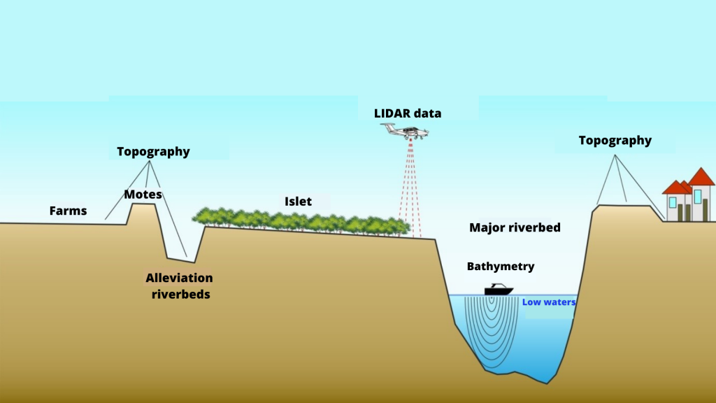
One of the works carried out for the study is the elaboration of a digital terrain model[1] (called DTM) that reproduces the current situation. It is important that this DTM faithfully reproduces the conditioning factors of the river section under analysis, and for this purpose the work listed below has been carried out.
First, the terrain is reproduced on a large scale, using LIDAR[2] topography, which consists of a scan of the terrain using aerial means (normally a light aircraft is used for large surfaces, but drones are commonly used).
Next, the topography of the most important elements for the study is obtained, such as: the crest of the dikes, walls, breakwaters, bridges, drains, etc. This work has been carried out using classical surveying methods, increasing the accuracy of the data in these key elements (Figure 6).
The DTM analysis has corroborated the existence of this dejection cone and the difficulty for the overflowed waters to return to the channel (Figure 7).
In the same way, the multiple crossing and drainage works existing in all the infrastructures have been inventoried and measured. A total of 50 works of this type have been studied in the section.
Hydraulic model
The next step of the study is the analysis of flooding episodes. Hydraulic models are used for this work, which consist of a computer tool that applies a given flow rate to the DTM and reproduces the effects of flooding[1].
In the case of this section of the Huecha River, there are no references of historical flood flows. On the one hand, the type of floods, of short duration and distributed throughout the entire discharge cone, make their measurement very difficult. On the other hand, there are no data on gauging stations[2], since the only existing one was built after the 2004 flood at Cortes and, due to its location, it only measures the flows that pass through the Huecha river under the railroad, located upstream.
For these reasons, an attempt has been made in this section to reproduce the flood that occurred in September 2004 and to propose actions to avoid affecting urban centers. The process by which hydraulic models attempt to reproduce a particular flood as closely as possible is called calibration. In this case, we have used the available images of the September 2004 flood and have reproduced different flood flows to obtain a flood similar to the one that occurred at that time (Figure 8).
In this case, the design flood for which the effects on urban areas are analyzed is that of 2004, which, according to the calibration carried out, assumed an approximate flow of 100 m³/s.
With respect to the problems that may be caused by possible overflows, it should be borne in mind that the hydraulic model considers the terrain to be rigid, i.e., the motes do not collapse at any time, even if they are overflowed. In this particular stretch, it should also be taken into account that the management of the irrigation system can condition to a large extent the behavior of the flooding. In this study, all irrigation tajaderas[1] were considered to be open.
The result of the modeling is discussed in section 4 “Study of Alternatives”.
STUDY OBJECTIVES
In accordance with the Ebro Resilience Strategy, the specific objectives of the study were as follows:
- Evaluate the level of protection of urban areas for a flood equivalent to that of September 2004.
- Propose actions to prevent flooding, in the event of flooding.
STUDY OF ALTERNATIVES
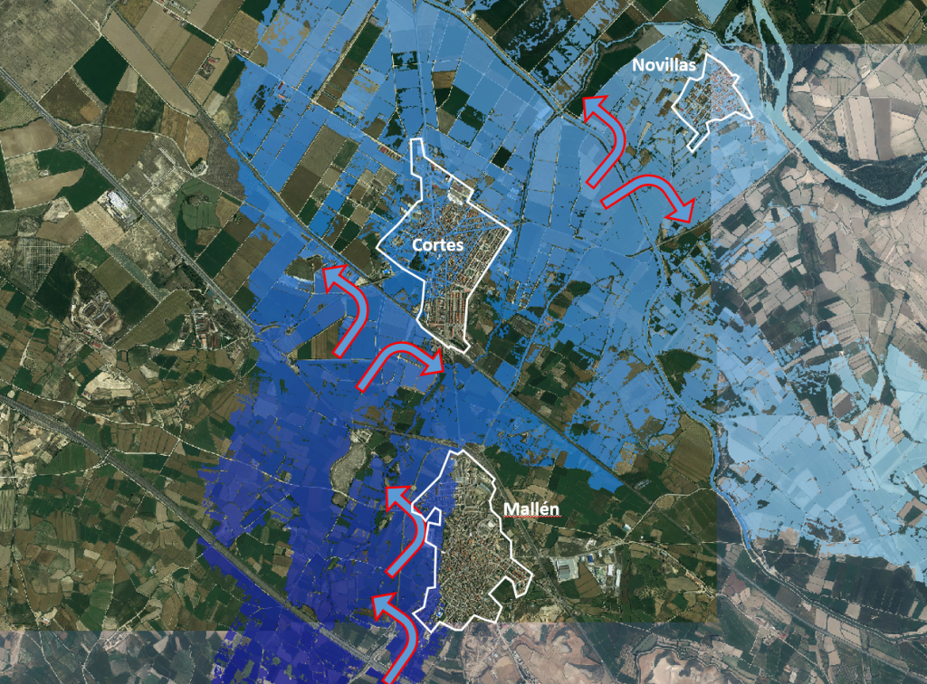
In the analysis of the simulation of the target flood, equivalent to the September 2004 flood (100 m3/s approximately), it is concluded that when the Huecha river reaches the Ebro alluvial plain, the overflowed waters spread and distribute over the entire width and length of the discharge cone, making it impossible for them to return to the riverbed (Figure 9).
In the same way, it can be seen how the transversal infrastructures enhance this phenomenon, acting as barriers, retaining the waters, extending the flooding and diverting them through their passage and drainage works.
Alternatives to avoid flooding of urban centers.
Several alternatives have been studied, aimed at protecting the population centers from the overflowing waters of the Huecha River.
As mentioned above, the flooding of the Huecha River extends across the entire width of the discharge cone and it is not feasible to try to contain it in the riverbed no matter how much its drainage capacity is increased in any of its dimensions (horizontal or vertical). Therefore, different alternatives have been studied to divert this overflow water away from urban areas (Figure 10).
The town of Mallén is located on one side of this cone. However, Cortes and Novillas are located within it, so they may be flooded and surrounded by water. This varied casuistry conditions the type of measures to be adopted.
The approach adopted in the design of the alternatives studied has been to use existing barriers (roads, highways, irrigation ditches, etc.) to create watertight perimeters surrounding the urban areas and diverting water to the lands adjacent to the town.
Alternatives to reduce the effects of infrastructures on flow
The above measures should be combined with the improvement of the permeability of many of the existing infrastructures. In many cases, these infrastructures will be used as an element of protection for urban centers, but the “dam effect” they produce increases the risk of infrastructure breakage and damage upstream, due to higher water depths.
Avoiding the flooding of urban centers will imply diverting flows to other less vulnerable areas, so it is necessary to plan for improved drainage capacity in these areas to avoid increased damage.
Description of the proposed alternative
The alternative that has been shown to be the most efficient in the simulations and that meets the established conditions is a combination of different actions.
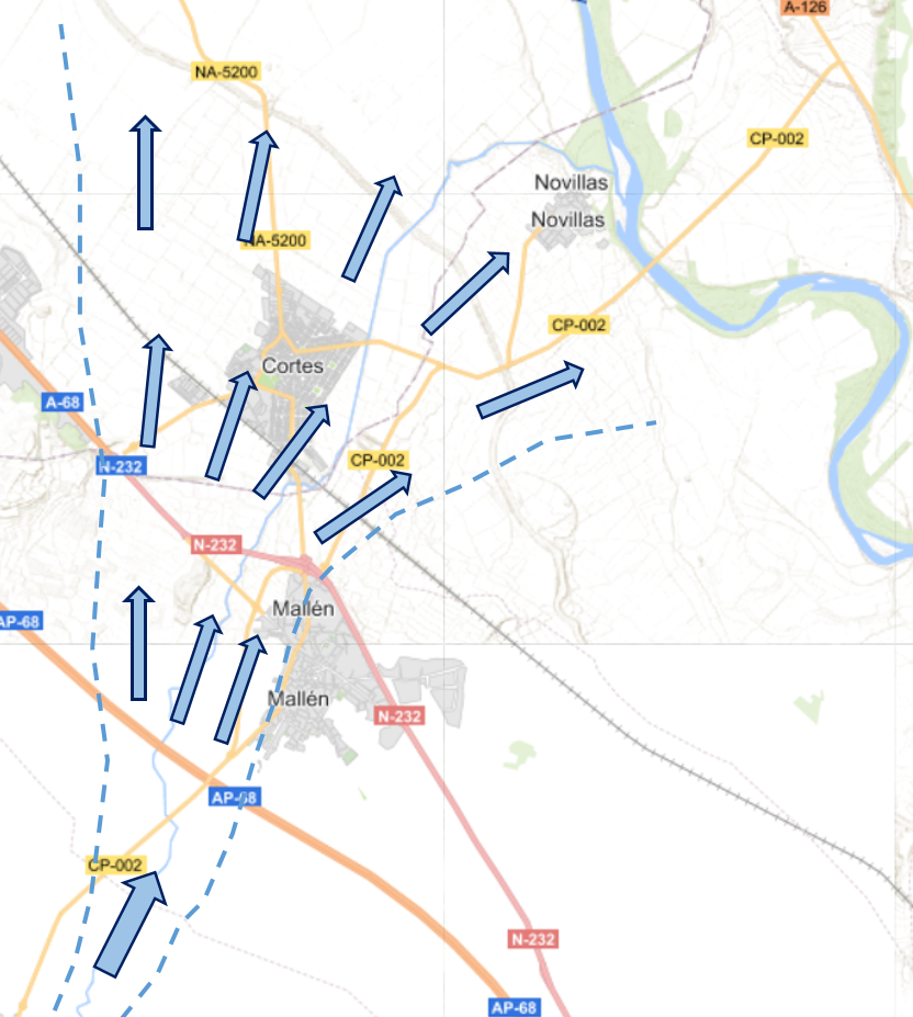
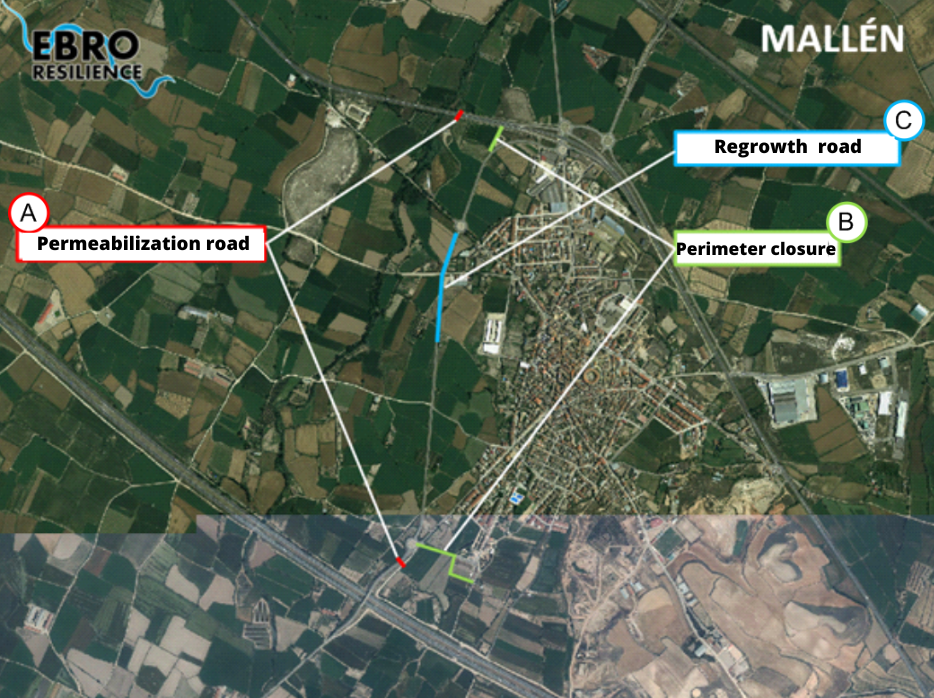
In the Mallén area, the actions would be as follows (Figure 11):
A. Permeabilization of the CP-02 road and the A-68 (N-232) highway. In the first case, to allow the waters accumulated near the population to pass through, and in the second case, to reduce the flooded area.
B. Perimeter closure of the urban nucleus, in two zones, to prevent water from reaching the urban area.
C. Regrowth of the CP-02 road at a low point that could be overtopped by water.
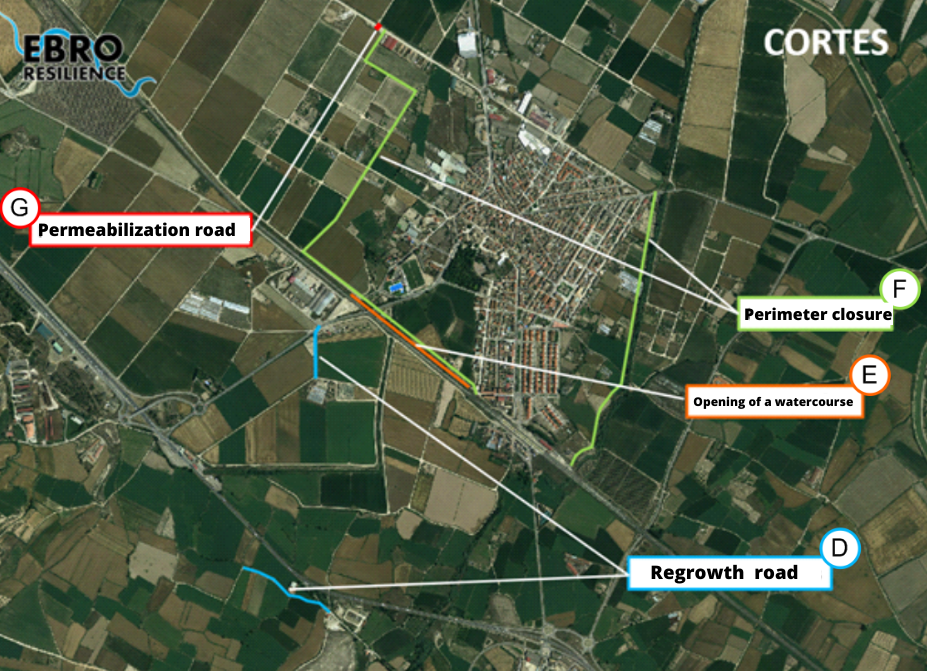
In the Cortes area, the actions would be as follows (Figure 12):
D. Roads to divert overflow waters to the west.
E. Opening of a watercourse to redirect the waters coming from the railroad works outside the urban area.
F. Perimeter closure of the urban nucleus by raising the Huecha hillock to the east and widening a road to the west.
G. Road permeabilization to avoid water accumulation.
For the preparation of the study, a series of technical studies have been carried out using the latest available technologies, which have made it possible to evaluate the current situation of the section with respect to the objectives set. Once the current situation has been evaluated, different alternatives for action have been studied, individually and in combination, selecting those that have produced the desired effects and discarding the less favorable or counterproductive ones.
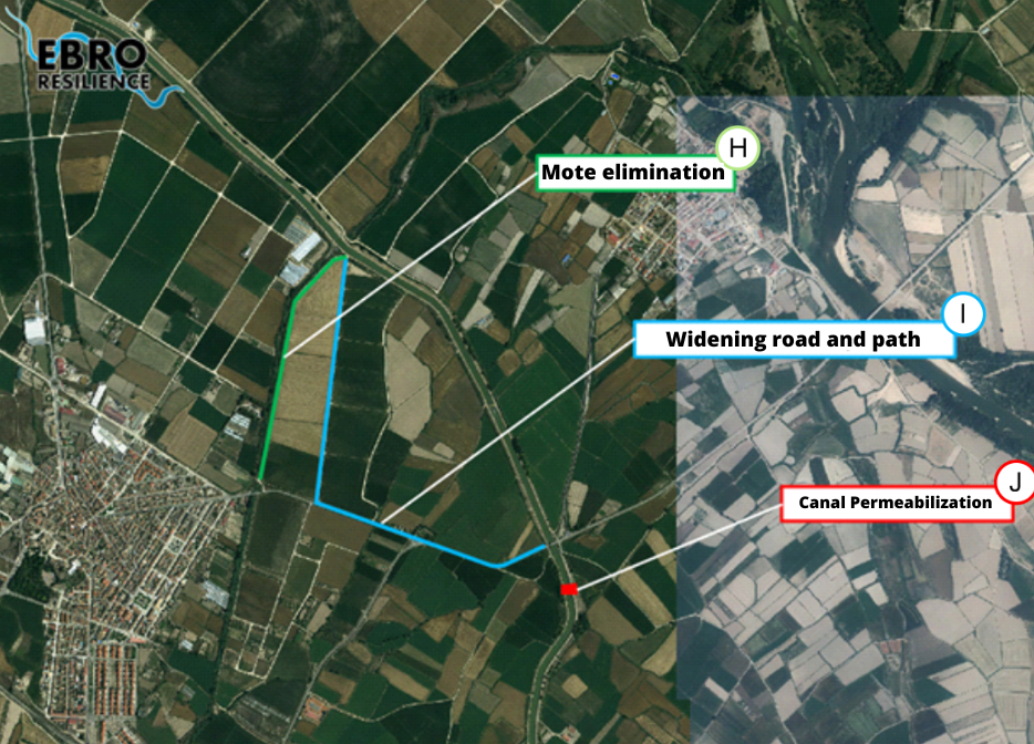
In the Novillas area, the actions would be as follows (Figure 13):
H. Elimination of the Huecha river mote that prevents the return of the overflowed waters, increasing the drainage capacity of the riverbed.
I. Widening of the CV-4/NA-5221 road and the road parallel to the Huecha riverbed. This will prevent water from entering the Canal Imperial de Aragón and overflowing into the urban center of Novillas.
J. Permeabilization of the Canal Imperial de Aragón to provide an outlet for the water derived from the road widening.
To begin the study, a digital terrain model9 (called DTM) is made to reproduce the current situation. It is important that this DTM faithfully reproduces the conditioning factors of the river section under analysis, and for this purpose the work listed below has been carried out.
CONCLUSION
The alternative selected as the most efficient would prevent the flooding of the urban centers of Mallén, Cortes and Novillas for floods equivalent to the one that occurred in September 2004.
The study has a pre-project level, being determined to select the most suitable alternatives and to allow the environmental evaluation of the proposed solutions. The definition of the exact dimensions of the actions to be carried out and their details must be included in the corresponding construction project.
The execution of these actions must be associated with a follow-up of their evolution that will make it possible to verify that the objectives pursued are achieved.
WHAT NOW?
Once the detailed study of the section has been completed, participatory meetings open to the public will be held to ascertain the opinion of the population.
The corresponding adjustments will then be made to the proposal, if necessary, and the environmental processing of the interventions will begin.
Finally, the construction projects will be drawn up and each Administration will implement, within the scope of its competences, the actions for a better management of the flood risk of the corresponding section.
[1] Movements of warm, moist air that rises up the mountainside and cools when it reaches a certain altitude. At that time, the water vapor condenses and clouds are formed.
[2] A current of water with high velocity and generally shallow draft that behaves in an impetuous manner.
[3] A noticeably flat or very gently sloping terrain that has been shaped by the sediments of a river over thousands of years.
[4] By flooding, from the deeper areas of the farm to the higher areas.
[5] The equivalent of a terrain model but in a digital environment.
[6] Acronym for Light Detection and Ranging or Laser Imaging Detection and Ranging.
[7] Elements that measure the amount of water passing through a particular section of the watercourse.
[8] The equivalent of pouring water into the model.
[9] Manually operated gates that allow or prevent the passage of water through an irrigation ditch.