Download Detailed Study – Section 14 (PDF)
Background and problems detected
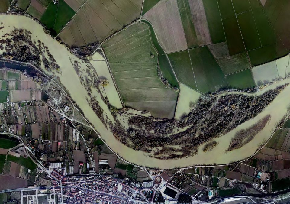
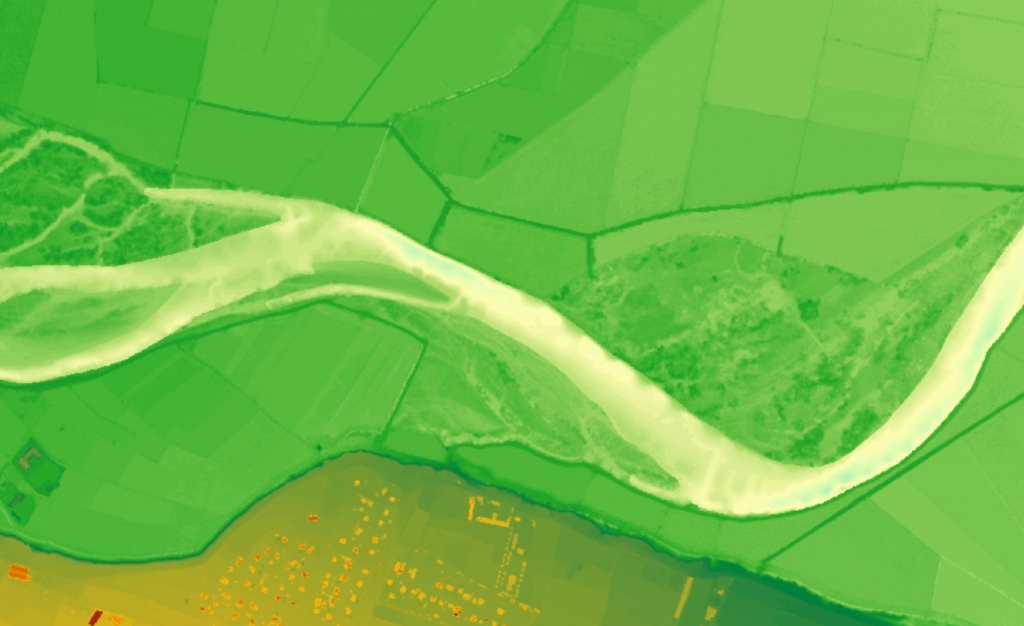
Within the scope of the Ebro Resilience Strategy, a total of 260 kilometers of the Ebro River are being studied, divided into 16 sections. Section 14 comprises the course of the Ebro River as it passes through the town of El Burgo de Ebro, with a length of 14 kilometers and encompassing the municipalities of Pastriz, El Burgo de Ebro, Alfajarín, Nuez de Ebro and Villafranca de Ebro (Figure 1).
The study of the present section 14 was initiated at the request of the City Council of El Burgo de Ebro, which highlighted the existence of an erosion problem in the defenses of the town, detected as a result of the flood of December 2019. Therefore, the problems and solutions proposed are focused on the causes that originated the study, although as a result of this work, other problems have been detected in addition to the initial ones, which will be addressed with the administrations involved in other spatial and temporal areas, in order not to delay the adoption of solutions to the problems that originated the preparation of the study.
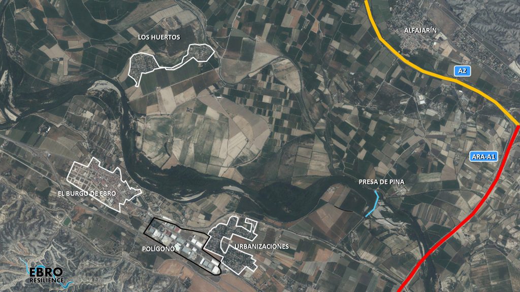
Figure 1. Study section on aerial photography of the PNOA 2018 (own elaboration).
At present, the defense dike on the right bank has an eroded front of about 1,800 meters, with varying degrees of affection (Figure 2). The first section is in apparently good condition, but it has lost almost all of its tree vegetation and the existing vegetation is excessively inclined towards the water, showing the effects of incipient erosion at the foot of the slope. In the second section, the one closest to the urban area, the breakwater that reinforces the motte has begun to slide, indicating a foundation failure. Finally, in the third section, which coincides with the last dike built and which directs the waters towards the left bank, the erosive process is visible to the naked eye. At the time of the visit, the soil and poplars bordering the water were falling into the water in succession.
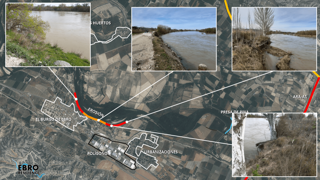
Figure 2. Current state of the defense of the right bank (own elaboration).
The collapse of this defense could cause the flooding of part of the urban area of El Burgo de Ebro, since it is located on a fluvial terrace that could be reached by floods.
Analysis of possible causes
Once the detected conditions have been exposed, it is necessary to study the possible causes of this problem, so that the intervention proposal derived from this study focuses on the correction of the causes and not on their consequences.
For the preparation of the study, a series of technical studies have been carried out using the latest available technologies, which have made it possible to evaluate the current situation of the section with respect to the objectives set. Once the current situation has been evaluated, different alternatives for action have been studied, individually and in combination, selecting those that have produced the desired effects and discarding the less favorable or counterproductive ones.
Geomorphological analysis
The landscape of the section is dominated by the gypsiferous formations that rise to the north of Alfajarín and to the south of El Burgo. Both formations rise above 250 masl and are approximately 6 km apart (white color in figure 3). The current Ebro River and its fluvial processes are located in these six kilometers, differentiating three levels of fluvial terraces. The first (brown color in figure 3) descends from the escarpment and is formed by the sediments contributed by the ravines that run from the gypsiferous formations to the Ebro River. The second (yellow color in figure 3), where the towns of Alfajarín and most of El Burgo de Ebro are located, is a terrace between 190 and 186 m above sea level that is difficult to reach by the Ebro floods. From this terrace there is a jump, abrupt on the right bank and softer on the left bank, of between 4-5 meters and the active terraces of the river begin (green color in figure 3). The latter terraces are where the current fluvial processes take place and are made up of more recent sediments (cobbles, gravels, sands and silts). In this area, approximately 4.5 km wide, the river has been meandering and forming meanders that are abandoned and formed anew after each major flood.
Human activity has historically adapted to these processes, as can be seen from the drawings that define the current agricultural plots (in areas where land consolidation has not been carried out), which allow us to guess the layout of the ancient meanders.
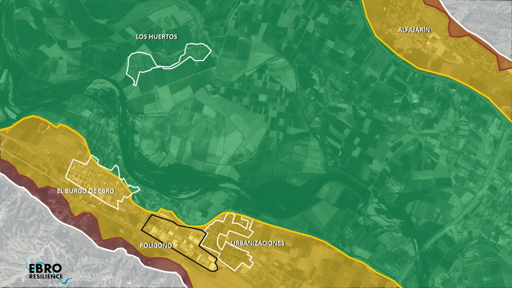
Figure 3. Different terrace levels in the study section (own elaboration).
Before the construction of the defense system, during floods the river was divided into two branches, occupying the entire flood plain.

Figure 4. Water flows deduced from the 1927 aerial photograph (own elaboration).
This circumstance can be seen in the 1927 aerial photograph (Figure 4), where there is evidence that, when it needed to expand its capacity, the river easily cut through the meanders and occupied the lower lands.
The construction of the system of defenses was aimed at preventing the flooding of large areas of land, in order to put them under cultivation (Figure 5). In this process, the existing natural flows were modified through the construction of dykes or dykes that diverted the direction of the current. As a result of the process, the waters were concentrated and directed towards the right bank, in the area where the urban area of El Burgo de Ebro is located.
This circumstance has accelerated the erosion process on the right bank, in which 40 ha of land have been lost since 1927 and 20 ha since 1956.
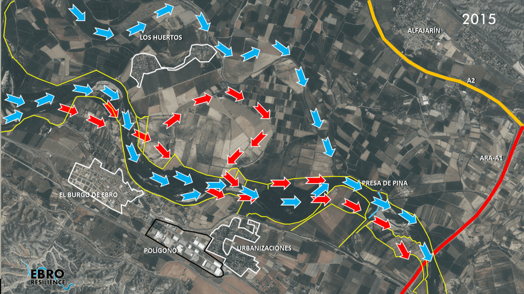
Figure 5. Water flows and defense system (in yellow) at present. The red arrows indicate the interrupted flows (own elaboration).
Digital Terrain Model (DTM)
One of the works carried out for the study is the elaboration of a digital terrain model (called DTM) that reproduces the current situation. It is important that this DTM faithfully reproduces the conditioning factors of the river section under analysis, and for this purpose the work listed below has been carried out.
First, the terrain is reproduced on a large scale, using LIDAR topography, which consists of a scan of the terrain using aerial means (normally a light aircraft is used for large areas, but drones are commonly used).
Next, the topography of the most important elements for the study is obtained, such as: the crest of the dikes, walls, breakwaters, bridges, drains, relief channels, safety perimeters, etc. This work has been carried out using classical surveying methods, increasing the accuracy of the data on these key elements.
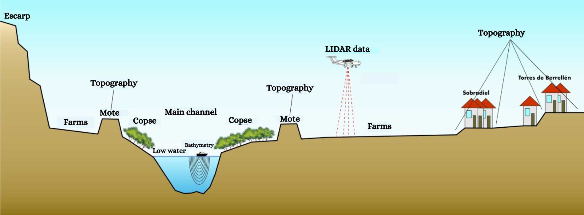
Figure 6. Diagram of data collection (own elaboration).
The above methods have the disadvantage that they are not able to obtain data from the ground beneath the water. This has been the main drawback encountered in previous flood studies. Technology is now available to obtain the topography of the river bed in a continuous manner. As a novelty for these studies carried out within the framework of the Ebro Resilience Strategy, aquatic means equipped with sonar have been used to collect bathymetric data from the bed of the riverbed, incorporating these data into the study. The data obtained are combined for the elaboration of the DTM (Figure 7).
The DTM analysis has corroborated the existence of the terrace levels observed in the field and has made it possible to detect the former course of the river. It is worth mentioning the presence of an arm that runs between the Los Huertos housing development and the A-2, which is activated for floods of around 2,000 m3/s of flow.
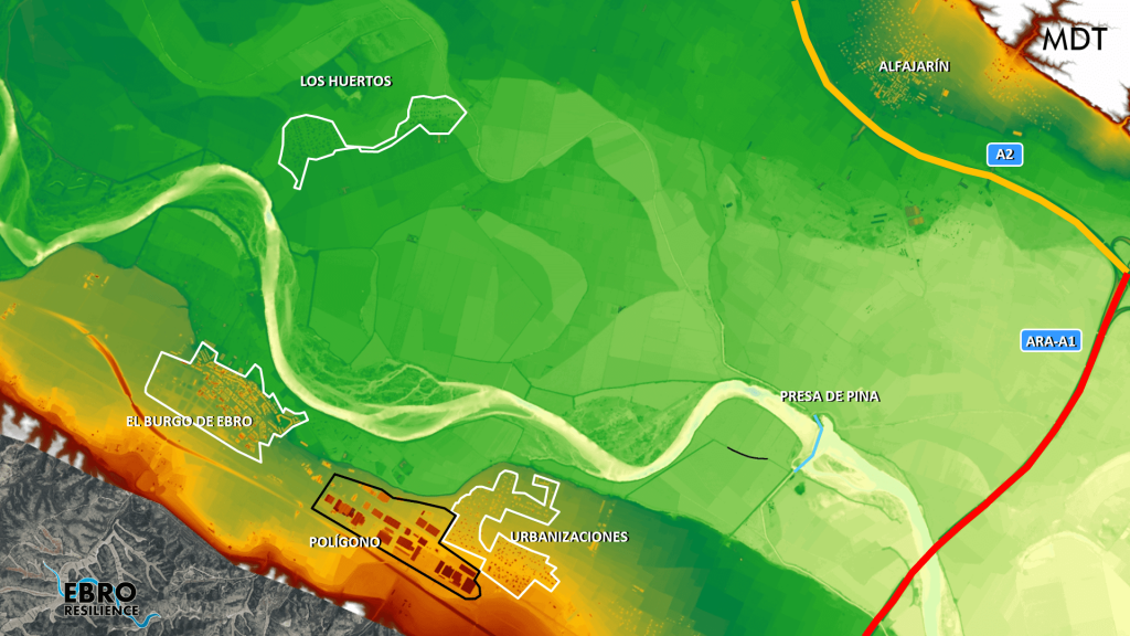
Figure 7. Fragment of the digital terrain model. White, reddish and orange colors indicate the highest zones and dark green, light green, light yellow and blue tones indicate the deepest zones, in that order (own elaboration).
On the other hand, bathymetry has confirmed the erosive processes on the El Burgo de Ebro defense (Figure 8) and has revealed other existing processes in those areas where the defenses have forced the main flow to modify its direction.
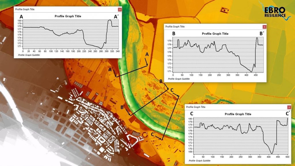
Figure 8. Transversal profiles in different sections of the defense of the town of El Burgo de Ebro (own elaboration).
A strong narrowing of the channel has also been detected, caused by the defense of the cultivated area of the Mejana de la Noria and the existence of dikes that function as a breakwater on the left bank. In that area the width between defenses is reduced from 440 to 200 meters and heavy erosion is occurring on the left bank (Figure 9).
 |
| Figure 9. Narrowing and erosion at the height of the Las Norias ditch (own elaboration). |
Hydraulic Model
The next step of the study is the analysis of flooding episodes. Hydraulic models are used for this work, which consist of a computer tool that applies a given flow rate to the DTM and reproduces the effects of flooding.
These computer tools require a process called calibration to adjust the results obtained to the characteristics of the section under study. In this case, the aerial photos of the avenue from April 2018 and December 2019 were used, achieving a good calibration.
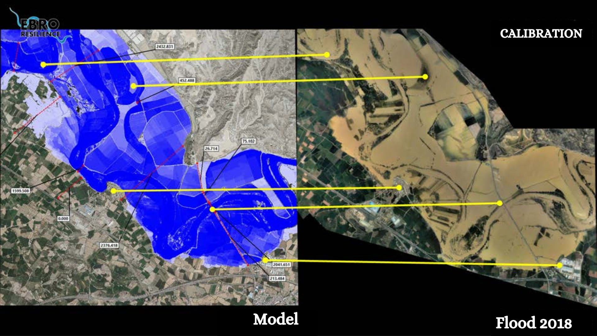
Figure 10. Example of calibration of a hydraulic model with the 2018 flood (own elaboration).
Once the hydraulic model has been configured and calibrated, the target flood is reproduced , in this case the one corresponding to a return period of 25 years, which in this section is equivalent to a flow of 2,700 m3/s, and the effects produced on urban areas are analyzed.
With respect to the problems that may be caused by possible overflows, it should be borne in mind that the hydraulic model considers the terrain to be rigid, i.e., the motes do not collapse at any time even if they are overflowed. To compensate for this circumstance, the flood peak in the simulation will be prolonged in time, achieving effects similar to those produced in a real event.
The result of the modeling is discussed in the “Study of Alternatives” section.
Objective of the study
In accordance with the Ebro Resilience Strategy, the specific objectives of the study were as follows:
- Evaluate the level of protection of urban areas for floods with a return period of 25 years.
- Propose actions to prevent flooding, in the event of flooding.
- To reduce the risk of defense collapse in the urban area by acting on the causes that give rise to it.
Study of alternatives
The analysis of the simulation of the target flood for a return period of 25 years (2,700 m3/s in this section) concludes that there are no effects on the urban area of the town of El Burgo de Ebro (Figure 11). The mapping of the National System of Flood Zones has shown that even for floods with a return period of up to 500 years, the urban center of El Burgo would be protected.
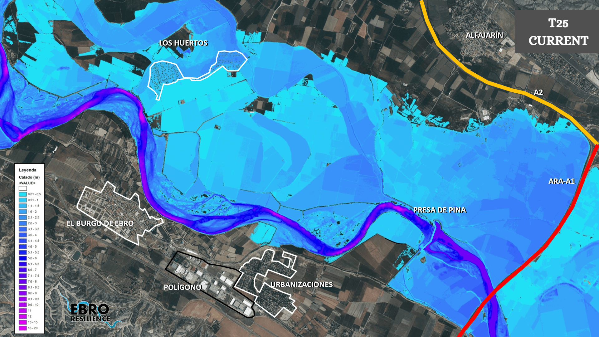
Figure 11. Results of the hydraulic model for the 25-year return period flood (own elaboration).
However, the modeling of the current situation has shown that there is an urbanized area, called “Los Huertos”, which suffers from flooding for floods of around 2,500 m3/s. This fact has been ascertained from 2018 aerial photographs of the avenue. The development is located on an old branch of the river, at a relatively low elevation even compared to the adjoining land.
The problems related to this urbanization will be addressed with the administrations involved in other spatial and temporal spheres, so as not to delay the adoption of solutions to the issues that led to the preparation of the study.
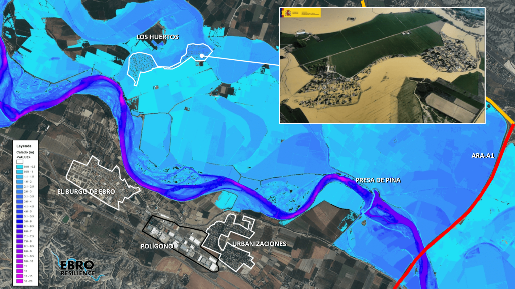
Figure 12. Flooding of the urbanization “Los -Huertos” in the modeling and during the flood of 2018 (own elaboration).
Consequently, it is appropriate to continue the analysis for the next objective, which will consist of studying alternatives to reduce the risk of collapse of the defense of the urban area of El Burgo de Ebro, acting on the causes that originate it.
To achieve this, it is necessary to reduce the amount of water that is diverted to the local defenses, reduce the velocity of water flowing over these defenses, or both simultaneously.
Alternatives to reduce the amount of water diverted to the defenses.
In the first case, several alternatives have been studied, aimed at actively contributing to the drainage of the avenue on the opposite side of the urban area. At present, this bank is protected by two dikes (in red in Figure 13) that oppose, almost perpendicularly, the flow of the current, diverting the waters towards the opposite shore. There are also some islands, which are growing and densely populated with vegetation on the left bank of the channel (in yellow in Figure 13).
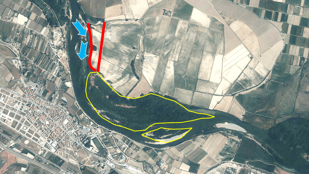
Figure 13. Dikes on the bank opposite the urban center, in red, and islands formed in the riverbed, in yellow (own elaboration).
Analyzing the result provided by the hydraulic model for the flow velocities for the flood under study, it can be seen that part of the current tries to flow towards the left bank, but is diverted by the levees towards the right bank (A in Figure 14).
As for the islands, the model shows that they have two differentiated parts in relation to the speed of water flow. In the upstream zone (B in Figure 14), the water flows between them at a similar velocity to that of other contiguous zones of the channel. In the final zone (C in Figure 14) there is a significant decrease in the flow velocity. This variation is induced by the presence of dike A, whose “protective” effect reaches this part of the islands. It is likely that part of the growth of the islands and the vegetation on them is a consequence of this phenomenon.
The study has proposed several alternatives for permeabilization of the left bank, by recessing the levees in various positions and constructing relief channels of various sizes and arrangements, as well as a combination of both solutions.
As for the islands, total or partial dredging of these sediment accumulations could be considered. In this case, the main problem would not be addressed since the levees would continue to divert water to the right bank. In the short term, the situation could improve, especially in the previous area, but in the medium term it would return to a situation similar to the existing one. The islands were not in their current location in aerial photographs of a few decades ago, so it can be deduced that their current size and position is a consequence of the modifications that the channel has undergone during these years and not the other way around.
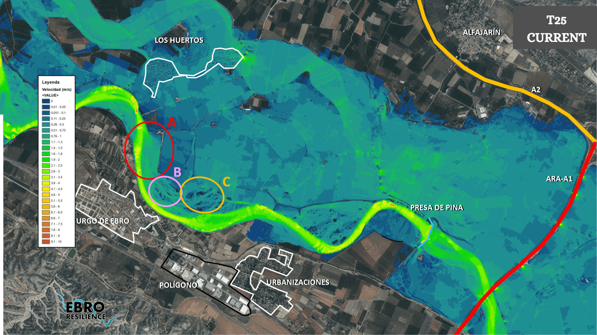
Figure 14. Velocity graph for the 25-year return period flood (prepared by the authors).
In addition to the above, the defense of the urban zone has suffered a significant erosion process, with depths exceeding 7 meters in some areas. Consequently, it does not seem advisable to dredge the sediment, which in a river always presents unknowns as to its future behavior. In other words, there is no guarantee that a spontaneous incision process cannot begin after dredging and end up affecting the defenses.
Finally, the area to be dredged is located within the Sotos y Galachos del Ebro Managed Nature Reserve, one of the specific protection objectives of which are the islands, or mejanas, of the Ebro. Any intervention that leads to a deterioration of these objectives requires a justification of the non-existence of other alternatives that could achieve the same results and a guarantee of success of the proposed solution. Both assumptions cannot be assured in the present case.
Alternatives to reduce the speed of water passing over the defenses.
To reduce the speed of water flowing over the defenses, the friction that the surface of the defenses opposes to the advance of the water can be increased or structures can be designed to directly reduce the speed of the water through opposition (breakwaters or similar).
In the first case, the presence of native riparian vegetation increases the friction of the water on the defense, reduces its velocity and protects the slope exposed to the water by arching branches and flexible stems in the direction of water flow. The establishment of this vegetation, even by means of continuous support, requires a wide time span (3 to 5 years) and is associated with a moderate water circulation speed, so that the vegetation can develop without suffering damage or being washed away during the first years. Therefore, a simple revegetation of the slope can be ruled out initially.
To solve these problems, there are bioengineering techniques[6] that incorporate the plant material as a functional part of the protective structure, which allows plants to develop with a greater guarantee. In this case, the living timber framed wall (known as Krainer wall) is an alternative that can be used to stabilize a hydraulic defense and increase the chances of successful revegetation. This wall consists of a succession of staples formed by interlocking wooden logs resting on a riprap base and filled with compacted earth. Cuttings, sticks and plants are inserted between the staples (depending on the height and their water requirements). If the planting thrives, the roots become entangled between the wood staples, increasing the strength of the structure by 60%.
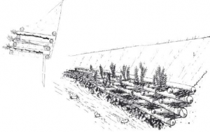
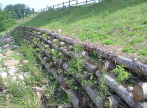 Figure 15. Half-timbered wall, sketch on the left (European Landscape Federation, 2007) and photo (aquanea.com).
The repair of the defense using traditional techniques, earthen dike and protective breakwater armor, prevents dense revegetation in the lower part of the dike. In addition, the stone offers a lower friction than the vegetation or the soil itself, achieving the opposite effect to the one desired.
Finally, the construction of rigid structures, such as breakwaters or similar, would be difficult to implement in the Nature Reserve and their operation would not meet all the needs: stabilization of the defenses, reduction of the speed of water circulation and integration into the protected area.
Description of the proposed alternative.
The alternative that has been shown to be the most efficient in the simulations and that meets the established conditions is a combination of interventions as follows (Figure 16):
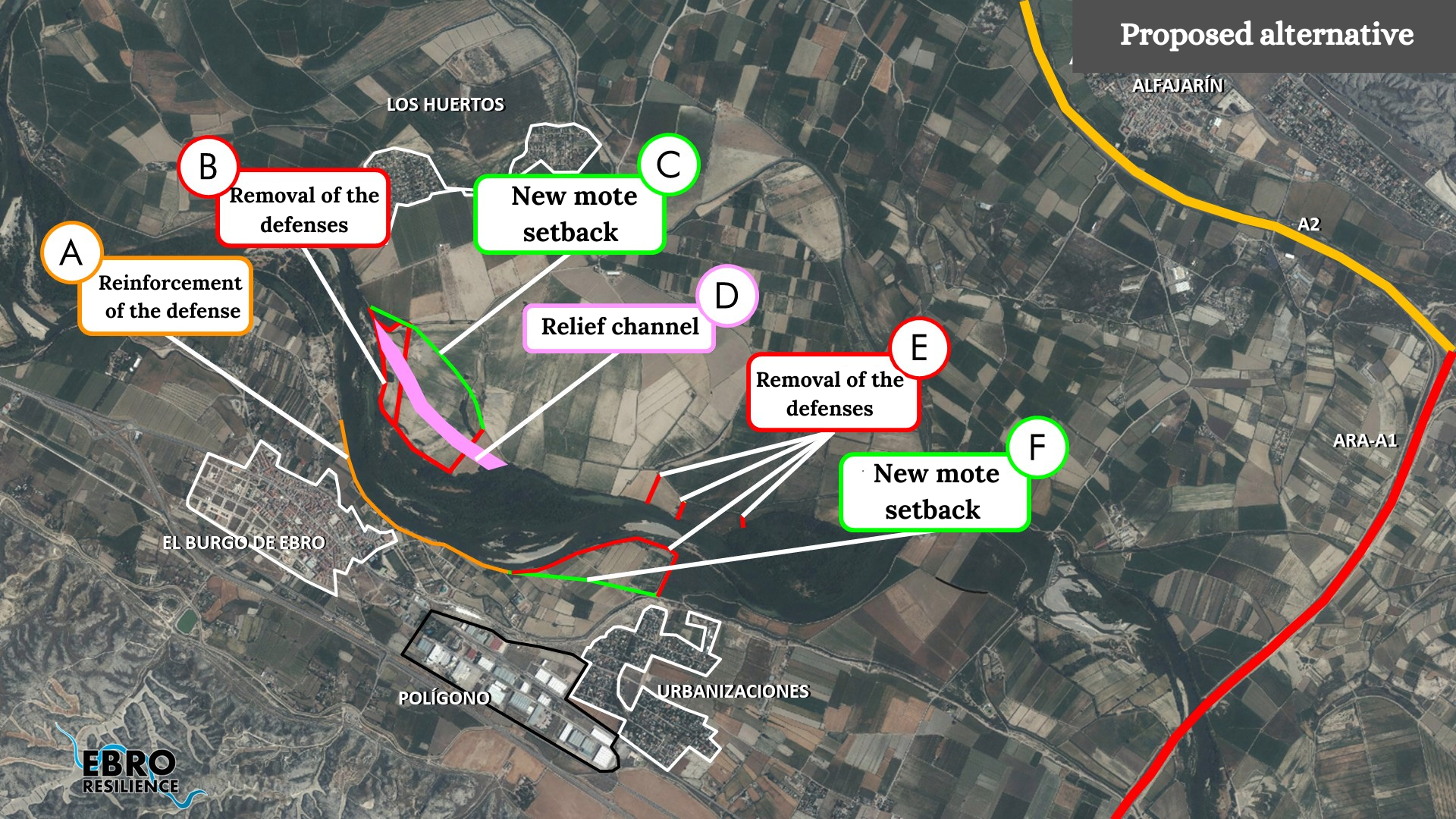
Figure 16. Proposed alternative (own elaboration).
- Repair and reinforcement of the existing defense with the construction of a Krainer wall.
- Removal of the defenses located in front of the town, to increase the fluvial space and allow the flow to pass in floods.
- Construction of a new recessed defense to delimit the flooded area.
- Execution of a relief channel on the left bank to facilitate the diversion of water towards the new open space.
- Retirada de las defensas que producen el estrechamiento aguas abajo de la población.
- Construction of a new recessed defense to delimit the flooded area.
Conclusion
The urban area of El Burgo de Ebro is not affected by floods with a return period of 25 years, achieving the objectives set out in the Ebro Resilience Strategy.
In this case, the proposal made is the implementation of combined actions to avoid the risk of collapse of the defense of the urban area.
What’s next?
Once the detailed study of the section has been completed, participatory meetings open to the public will be held to ascertain the opinion of the population.
The corresponding adjustments will then be made to the proposal, if necessary, and the environmental processing of the interventions will begin.
Finally, the construction projects will be drawn up and each Administration will implement, within the scope of its competences, the actions for a better management of the flood risk of the corresponding section.