BACKGROUND
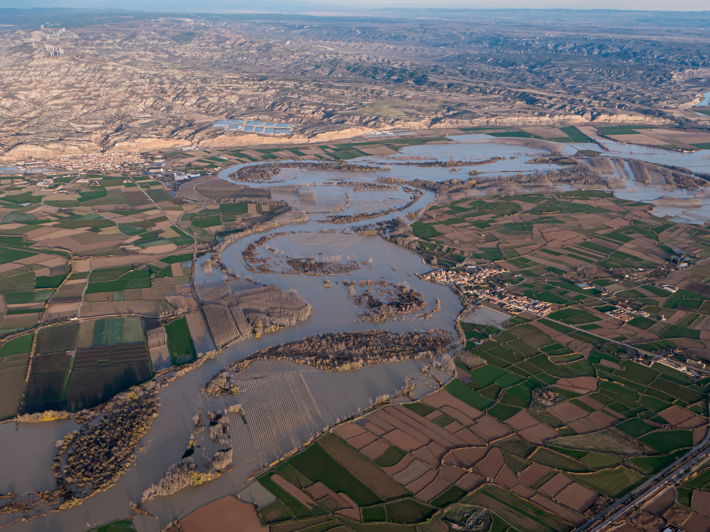
The Ebro River flows through a flat and fertile plain between the towns of Luceni, Alcalá de Ebro and Remolinos, maintaining a distance of about 3 km from the gypsiferous escarpment located to the north, in the section between Luceni and Alcalá, and which it approaches on its way to Remolinos, in this plain, the river meanders describing large meanders whose proximity to the urban centers has varied throughout history.
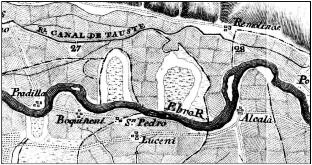
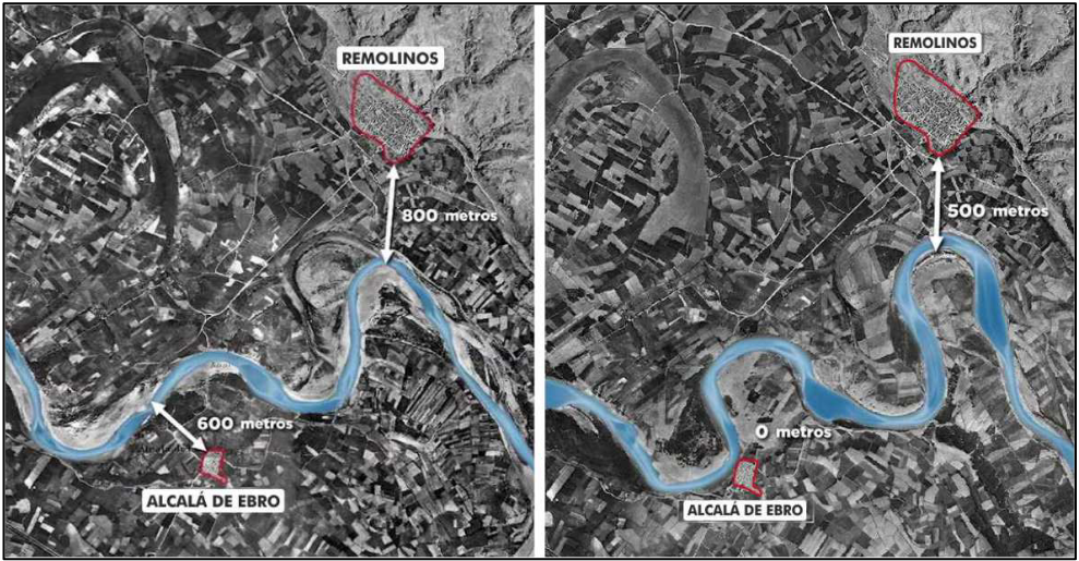
In the last hundred years the riverbed has again approached the town of Alcalá de Ebro and a similar trend, although less pronounced, is occurring in the case of Remolinos (Figure 2). All of this despite the flood defense works carried out during the 1960s to 1990s (mainly seawalls1, breakwaters and dykes), and the construction of a number of new flood protection structures in the area.2 and breakwaters3).
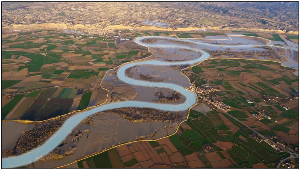
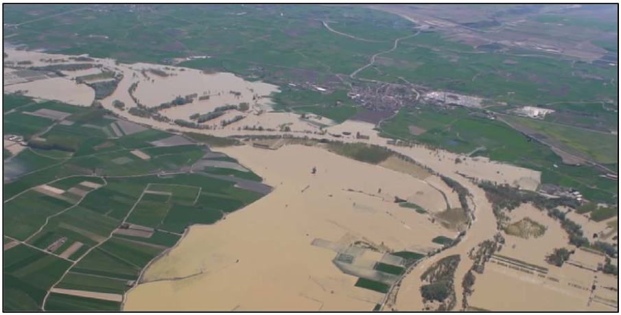
In flood episodes close to the ordinary flood, the river overflows and floods the river plain. The extent of the flooded surface area depends on the river flows and the temporal duration of the episode, but since it is a flat plain, it is common for the water to occupy a large area (see Figure 3).
- Luceni
The town of Luceni, located on the right bank of the Ebro, is at an elevation4 higher than that of the opposite bank and at a distance of 4.5 km from the escarpment. This means that the flood plain on the left bank can absorb a large volume of water (Figure 4), preventing the overflowing waters from reaching the urban center even for floods with a high return period5.
- Alcalá de Ebro
In the case of Alcalá de Ebro, the evolution of the river has brought the riverbed to the gates of the town. At present, the urban center is protected from the river floods by a defense dike and a battery of breakwaters.
The crest of the main defense dike is located at 223.3 meters above sea level.6, while the streets around the levee reach 221.0 m above sea level, so that, in major avenues, the streets of the town may be at a lower elevation than the water flowing through the channel.
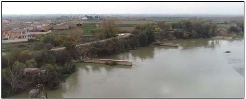
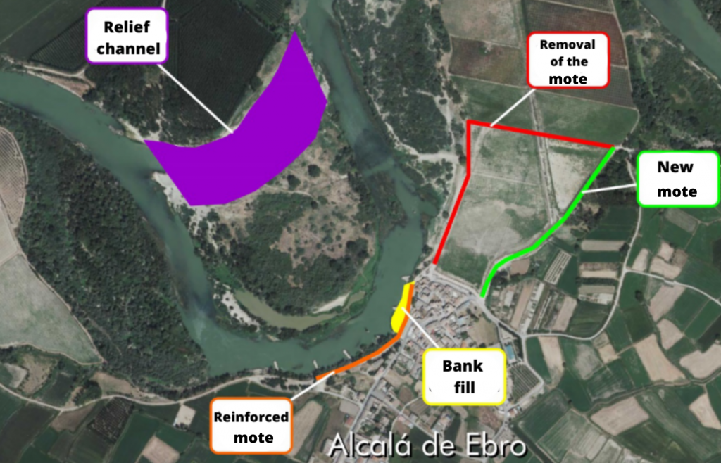
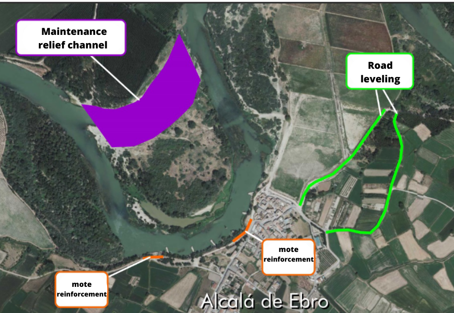
Following the major floods of 2015, the defense dike of the urban area was reinforced by consolidating it through the application of resin injections7. The dike located immediately downstream of the town, which defended a productive poplar grove, was also removed and was built set back some 200 meters. Finally, a relief channel8 was built in the meander in front of the town to reduce the amount of water flowing in front of the town’s defenses. The surplus material was used to reinforce the bank between the most deteriorated breakwaters.
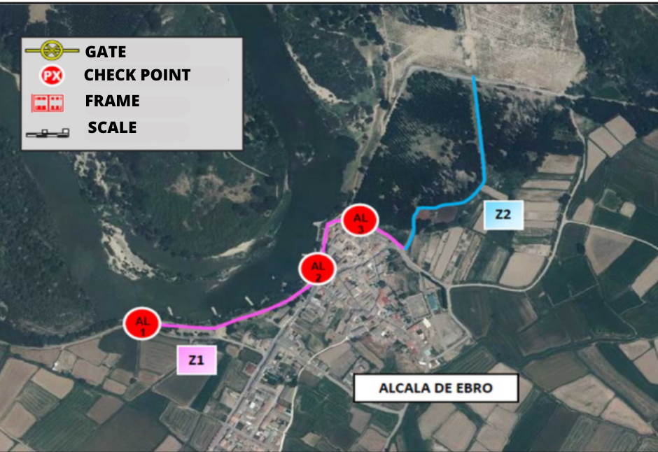
In 2017, a population security perimeter was delimited (see Figure 7). This safety perimeter consists of the delimitation of the defense structures of the urban core, their leveling, their preparation to be able to carry out emergency works with guaranteed safety and the construction of a system of milestones marked with a scale, which serve to control the levels of the avenue and help in monitoring its evolution and decision making.
In the same way, after the flood of 2018, the seawall defending the town was again ref ormed. Maintenance work was carried out on the relief channel and roads located to the northeast of the town were leveled to avoid cutting off the possible backflow of the overflowing waters towards the urban center (Figure 8).
Currently, and in spite of the interventions carried out, the population of Alcalá de Ebro is vulnerable to floods with a return period of 10 years, according to the hydraulic studies carried out.
- Remolinos
In the town of Remolinos, the main risk of flooding comes from possible marginal overflows that advance along the flood plain from upstream areas and could reach the urban area. To reduce this possibility, after the 2015 floods, a safety perimeter was formed by joining, consolidating and leveling defense dikes, existing and newly constructed roads (Figure 9).
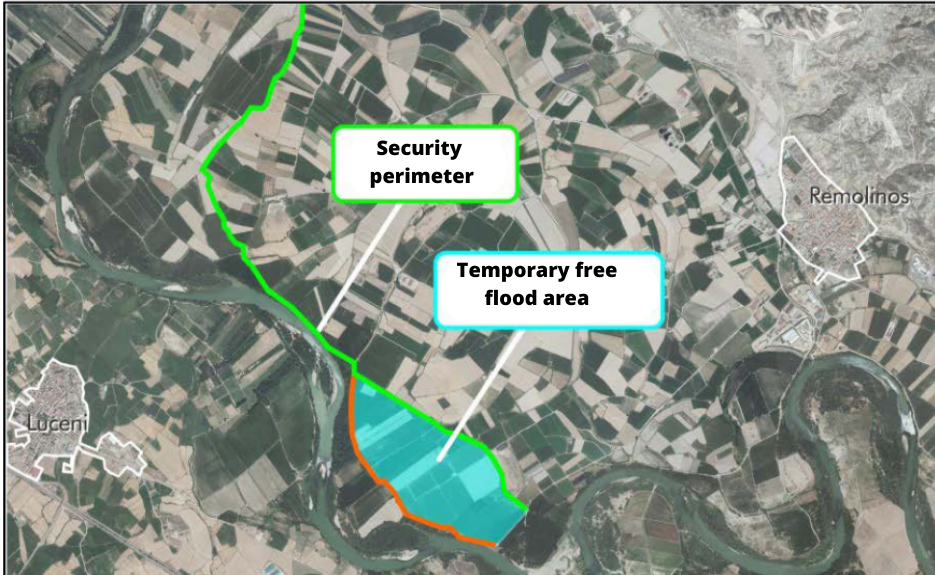
After the 2018 floods, this perimeter was maintained and a temporary free flood area was created in the outer zone to reduce flood damage to the farms included in the perimeter.
At present, the town of Remolinos is protected for floods with a return period of 10 years, according to the hydraulic studies carried out.
Objectives of the study
Within the scope of the Ebro Resilience Strategy, a total of 260 kilometers of the Ebro River are being studied, divided into 15 sections.
Section 7 focuses on the towns of Alcalá de Ebro and Remolinos, since the urban area of Luceni is outside the flood zone. The section studied runs from the Boquiñeni meander to upstream of the town of Cabañas de Ebro, with a total length of 16 km.
Los objetivos específicos del estudio realizado han sido:
- Evaluate the level of protection of the urban areas of Alcalá de Ebro and Remolinos for floods with a return period of 25 years.
- Propose actions to prevent flooding, in the event of flooding.
- To analyze the erosion processes of the defenses of the town of Alcalá de Ebro and to propose actions to reduce them in case these processes are detected.
- Reduce the risk of flooding in non-urban areas by reducing the speed at which water flows and/or the height that floods reach over fields.
Work performed
For the preparation of the study, a series of technical studies have been carried out using the latest available technologies, which have made it possible to evaluate the current situation of the section with respect to the objectives set. Once the current situation has been evaluated, different alternatives for action have been studied, individually and in combination, selecting those that have produced the desired effects and discarding the less favorable or counterproductive ones.
- Digital Terrain Model (DTM)
To begin the study, a digital terrain model9 (called DTM) is made to reproduce the current situation. It is important that this DTM faithfully reproduces the conditioning factors of the river section under analysis, and for this purpose the work listed below has been carried out.
First, the terrain is reproduced on a large scale, using LIDAR10 topography, which consists of a scan of the terrain using aerial means (normally a light aircraft is used for large areas, but drones are commonly used).
Next, the topography of the most important elements for the study is obtained, such as: the crest of the dikes, walls, breakwaters, bridges, drains, relief channels, safety perimeters, etc. This work has been carried out using classical surveying methods, increasing the accuracy of the data on these key elements.
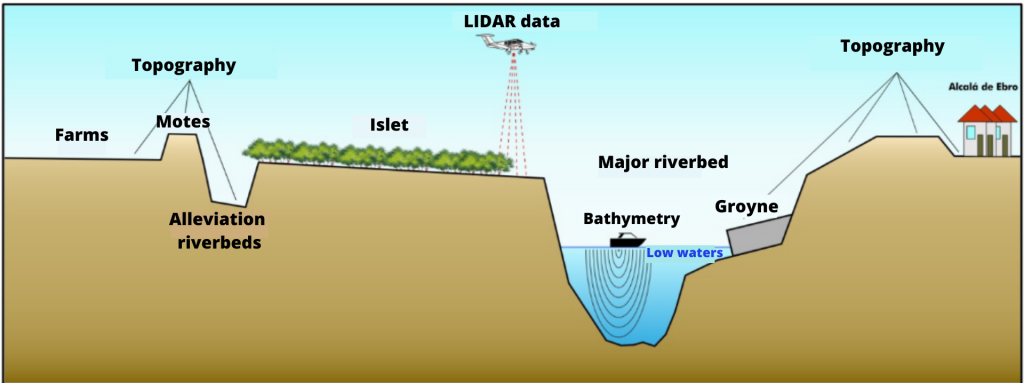
The above methods have the disadvantage that they are not able to obtain data from the ground beneath the water. This has been the main drawback encountered in previous flood studies. Technology is now available to obtain the topography of the river bed in a continuous manner.
As a novelty for these studies carried out within the framework of the Ebro Resilience Strategy, aquatic means equipped with sonar11 have been used to collect bathymetric data12 from the bed of the riverbed, incorporating these data into the study.
The data obtained are combined for the elaboration of the digital terrain model.
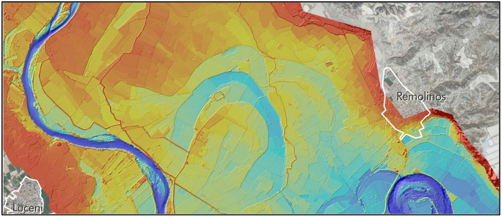
The DTM analysis has corroborated that, in the case of Remolinos, the topography of the flood plain directs the overflow waters in the area of Carladero (Boquiñeni) towards the urban center, through the layout of old meanders.
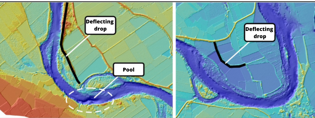
The presence of two mottles that prevent the flooding of two meander lobes under cultivation has also been detected (Figure 12). The first of these is located on the left bank, opposite the town of Luceni. This defense produces a double narrowing in the low water channel, reducing the effective drainage section by 25%, producing a pool in the narrowest area and directing the water towards the opposite bank. The second defense is located in the meander located downstream of Alcalá de Ebro, also on the left bank. This mote does not cause a marked narrowing of the riverbed, but its deflecting effects must be studied as it diverts the waters towards the bank where the urban area of Alcalá de Ebro is located.
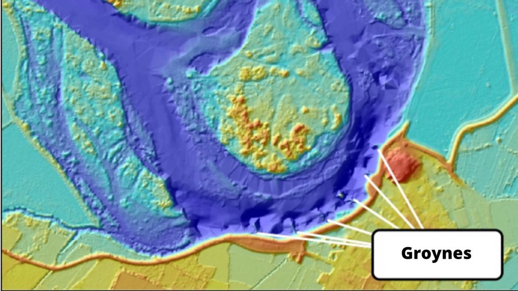
Finally, the bathymetries show that the battery of breakwaters integrated in the defense of Alcalá de Ebro is working properly and prevents erosion of the convex part of the meander from advancing towards the dikes of the town (Figure 13).
- Hydraulic model
The next step of the study is the analysis of flooding episodes. Hydraulic models are used for this work, which consist of a computer tool that applies a given flow rate to the DTM and reproduces the effects of flooding13.
These computer tools require a process called calibration to adjust the results obtained to the characteristics of the section under study. In this case, the aerial photos of the avenue from April 2018 and December 2019 were used, achieving a good calibration.
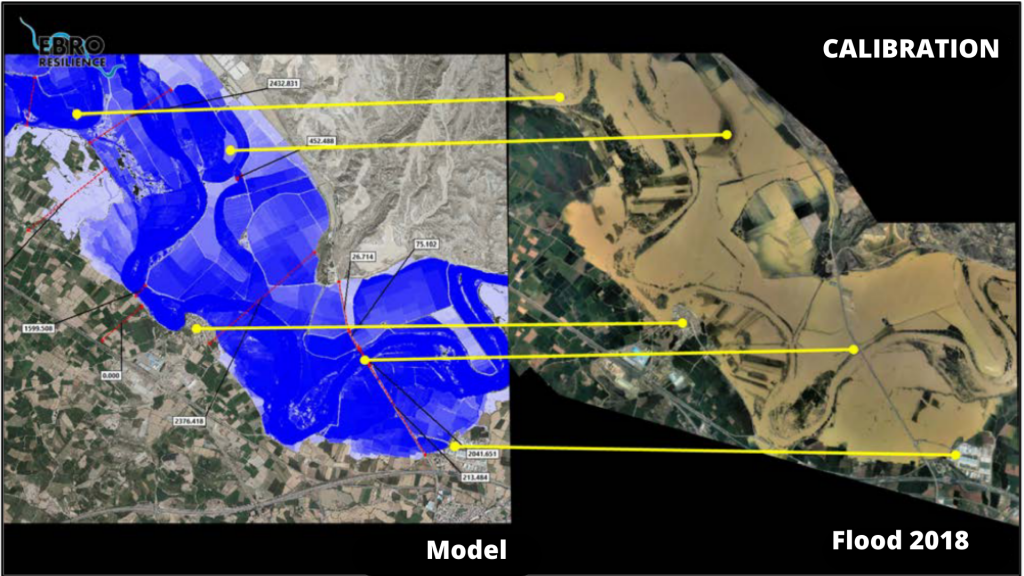
Once the hydraulic model has been configured and calibrated, the target flood is reproduced, in this case the one corresponding to a return period of 25 years, which is equivalent to a flow of 3,100 m3/s in this section, and the effects produced are analyzed.
Study of alternatives
The simulation of the target flood (3,100 m3/s in this section) showed that the urban area of Alcalá de Ebro would be flooded in two ways. The first was due to a lateral overflow that would occur on the road from Alcalá to Luceni and would move downstream through the fields until it reached the town on its west side. The second by an overflow that would reach the population along its northeast front, between the two roads leveled in 2018.
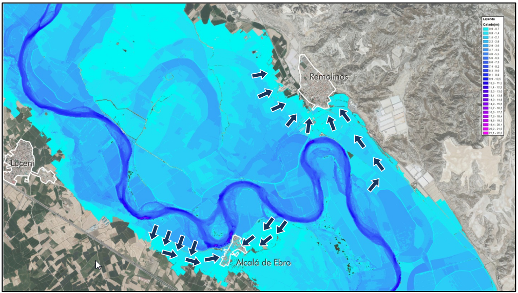
In the case of Remolinos, the model shows that water would minimally reach the urban area. However, the waters would practically reach the town, the most worrisome being the overflow that occurs in the section downstream of the town, on the left bank of the river, which recedes through the fields until it reaches the urban area.
In addition, analyzing the modeling results, the influence of the deflector mote located in the meander in front of the town of Alcalá de Ebro on the overflow towards the right bank, which ends up reaching the town on its northeast side, has been confirmed.
Once the data obtained have been used to determine the problems identified in advance, several alternatives with different actions are simulated. For each alternative studied, the DTM is modified, incorporating the hypothetical actions to be undertaken, and the target flood is reproduced again on the modified terrain, comparing the results obtained with the previous ones and evaluating whether the expected improvement is achieved.
If this is not the case, the proposal is rejected. The actions that do prove to be favorable to the objectives pursued are also simulated in a combined form, to check whether their integrated effect is more favorable, neutral or whether the proposals cancel each other out.
Finally, the alternative that has been shown to be the most efficient in the simulations is a combination of interventions as follows (figure 16)
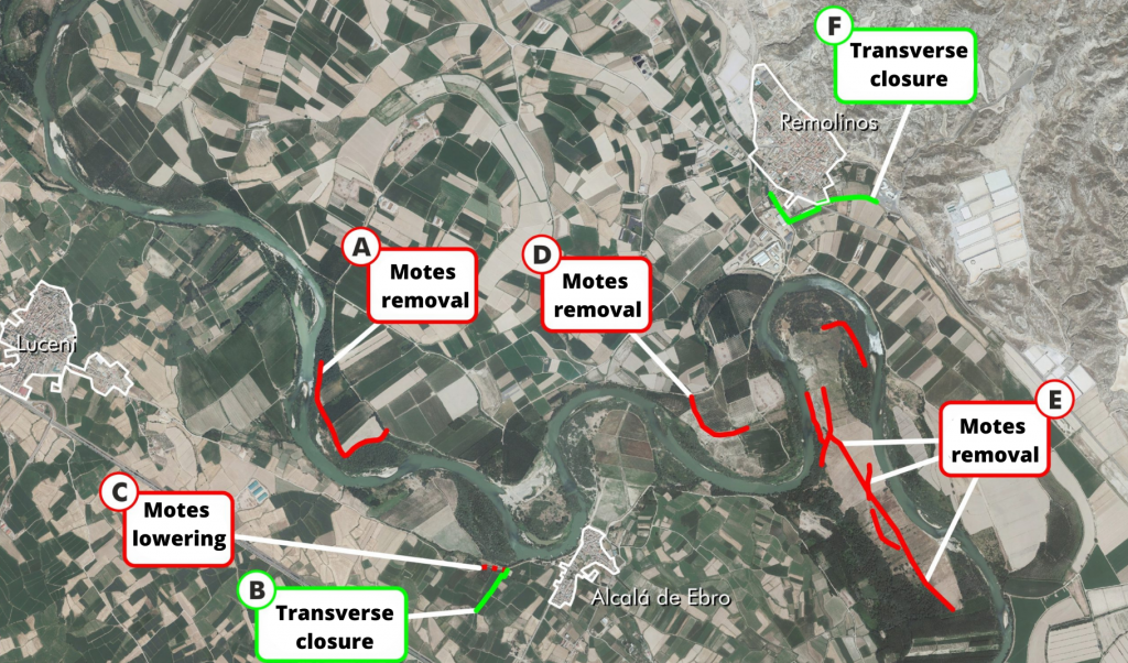
- Removal of the deflector mote located in front of Luceni, to improve the general flow of water and reduce the erosive process suffered by the right bank and the bed of the riverbed.
- Construction of a transversal closure to prevent the lateral overflow on the right bank from reaching the urban area of Alcalá de Ebro. This closure will be carried out by widening an existing road and building a new section that will connect the widened road and the existing defense.
- Lowering of the existing defense in the section immediately upstream of the transversal closure. The purpose of this lowering is to avoid that, in the event of a flood with a higher flow rate than the one studied, the waters overflow the transversal closure and reach the urban area or, even worse, that the overflowing of the transversal closure may cause it to break and the retained waters may suddenly flow towards the urban area, increasing the damage. By means of this lowering, the overflowed waters would return to the river at this point, which would be at a lower level than that of the transverse closure.
- Removal of the deflector mote located on the left bank, in the meander in front of the town of Alcalá de Ebro. The removal of this defense will considerably reduce the overflow of water to the right bank and prevent it from reaching the urban area of Alcalá de Ebro.
- Removal of the remains of defenses, roads and other obstructions to the passage of the stream in the “Las Rozas” meander. These remains hinder the flooding of the meander, favoring the overflow towards the right bank. They also produce flow concentrations in areas where the defenses are damaged, which increase the erosive processes in the meander itself and on the left bank. This action was proposed by the participants and obtained a good rating in the participatory process that took place in 2018.
- The flooding of Remolinos on its southeast side is shown to be the most likely. Therefore, the construction of a transversal closure for the urban area on its southeast side is proposed. The closure will be supported on existing roads, although some new sections will have to be added.
Conclusion
The alternative selected as the most efficient would prevent the flooding of the urban centers of Remolinos and Alcalá de Ebro for floods with a return period of 25 years, achieving the objectives set out in the Ebro Resilience Strategy.
In addition to the above, with the improvement in water flow that would be achieved, for the target 10-year return period flood, 141 ha of agricultural plots that are now flooded would no longer be flooded (11% of the farms in the section) and the height of the water over the fields would decrease in 87% of the farms in the section under study. Thus, 98% of the agricultural plots under study would see their flooding conditions improved.
The study has a pre-project level, being determined to select the most suitable alternatives and to allow the environmental evaluation of the proposed solutions. The definition of the exact dimensions of the actions to be carried out and their details must be included in the corresponding construction project.
The execution of these actions must be associated with a follow-up of their evolution that will make it possible to verify that the objectives pursued are achieved.
What’s next?
Once the detailed study of the section has been completed, participatory meetings open to the public will be held to ascertain the opinion of the population.
The corresponding adjustments will then be made to the proposal, if necessary, and the environmental processing of the interventions will begin.
Finally, the construction projects will be drawn up and each Administration will implement, within the scope of its competences, the actions for a better management of the flood risk of the corresponding section.
1 Structure formed with earth, in the form of an embankment, whose predominant dimension is longitudinal and that protects from frontal overflow. Locally known as motes.
2 A structure built on the bank of a river or on the coast of the sea, which protrudes perpendicular to it and whose function is to defend the banks or modify the current.
3 Structure made up of large stone blocks.
4 Height above sea level in Alicante.
5 Average time it takes to produce a flood of similar flow.
6 Meters above sea level in Alicante.
7 A glue-like chemical product that is injected into the body of the dam.
8 Artificial river branch that comes into operation during flooding.
9 The equivalent of a terrain model but in a digital environment.
10 Acronym of Light Detection and Ranging or Laser Imaging Detection and Ranging.
11 An element that obtains the depth of the bottom of the sea or a river by emitting sounds and measuring their reflection.
12 Topography performed underwater.
13 The equivalent of pouring water into the model.